ORIGINAL ARTICLE
NUNES, Antônio José Ribeiro [1]
NUNES, Antônio José Ribeiro. The use of geoprocessing: geographic information system in mining. Revista Científica Multidisciplinar Núcleo do Conhecimento. Year. 07, Ed. 06, Vol. 03, p. 165-178. June 2022. ISSN: 2448-0959, Access link: https://www.nucleodoconhecimento.com.br/technology-en/geoprocessing
ABSTRACT
In recent years, society and productive means have experienced a great technological advance through the availability of various equipment and computerized systems that have expanded the ability to communicate and solve problems through access to data and information. Among these advances, geoprocessing stands out, due to its ability to collect, store, share and analyze data, including its application in planning the exploration of deposits, assessment of environmental impacts, control and operational management of mining activities. An analysis of geoprocessing tools from the perspective of their contribution to mineral research and prospecting, structural assessment of mineral deposits, geotectonic information in areas of occurrence of mineral deposits for exploration, selection of anomalies, geological surveys, surveys and surveys of mineral reserves. Given this context, this article aimed to answer the following guiding question: What is the contribution of geoprocessing to mining companies in terms of commercial exploitation and environmental recovery of areas degraded by mining activities? Therefore, the objective of this article is to identify the application of geoprocessing tools in mining activities. Thus, in order to respond to the objectives of the study and the problem pointed out, it was decided to carry out a bibliographic research based on the authors’ theoretical foundations. It was intended to point out the concept, foundations and tools used in geoprocessing; evaluate the application of geoprocessing in Brazilian mining; to analyze the contribution of geoprocessing in reducing the environmental impacts of mining activities. The application of geoprocessing in Brazilian mining contributes to optimizing management through information, mineral research and prospecting, discovery of mineral deposits, exploration planning of mineral deposits, evaluation and determination of economic advantages, interpretation of mining areas, simulations of landscapes that they help in the evaluation of before and after the exploration with a view to the recovery of degraded environments. The application of geoprocessing tools in mining activities makes it possible to prepare mapping, images and diagramming, which are carried out in areas destined for mining exploration, mineral prospecting and evaluation of mineral deposits, being, therefore, unquestionable as to the ability to produce satisfactory results.
Keywords: Geoprocessing, Mining, Environmental Impacts, Prospecting, Mineral Deposits.
1. INTRODUCTION
Geoprocessing and the Geographic Information System (GIS) have produced in the computerized society a greater democratization of knowledge, favoring the expansion of articulations of networks that started to assist various activities that depend on information, as well as the expansion of the fields of knowledge.
The information and images made available by technology through the application of research with the Geographic Information System – (GIS), allowing a broad scenario for decision-making in the field of social, environmental, legal and other research (ARAÚJO, 2017).
The study will try to investigate the production of this new knowledge based on the assumption that its affirmation in Brazilian society has brought a great contribution through the use of information, maps and images that present georeferenced coordinates orientations that allow the knowledge of the territory and control points that favor the creation of support frameworks for the establishment of demarcations.
The objective of this article is to identify the application of geoprocessing tools in mining activities. It was intended to point out the concept, foundations and tools used in geoprocessing; evaluate the application of geoprocessing in Brazilian mining; to analyze the contribution of geoprocessing in reducing the environmental impacts of mining activities.
From this perspective, the study is limited to an analysis of these tools from the perspective of their contribution to mineral research and prospection in deposits, structural assessment of mineral deposits, geotectonic information in areas where mineral deposits may exist for exploration, selection of assets (anomalies ), geological surveys, research and drilling of mineral reserves.
The research problem seeks to investigate the following question: What is the contribution of geoprocessing to mining companies in terms of commercial exploitation and environmental recovery of areas degraded by mining activity?
In order to respond to the objectives and the guiding question of the research, it was decided to carry out as a methodology a bibliographic research based on the theoretical assumptions of the authors.
The assumptions of the study indicate that geoprocessing tools are essential for mining companies in management decisions, regarding socio-environmental and economic responsibilities.
The social importance of the study is justified based on the assumption that the knowledge obtained in the mining activity is part of the needs of companies insofar as it scales perspectives for its application in all sectors of socio-environmental and economic responsibility.
In this way, the study will recognize the importance of applying technological systems in production, integrating the availability of means and resources for the application of analysis processes that favor mineral exploration without compromising the environment, applying the images and simulations of the Information System Geographical (GIS) representations of before and after mineral exploration, which can provide a scenario of the real phenomenon and the need for procedures regarding the recovery mechanism of the area in its natural landscape.
The academic relevance is to demonstrate the contribution of technologies that are part of the set of georeferenced information for application in companies from their needs, having placed the issue of mining companies and their challenges facing the efficient use of information.
2. DEVELOPMENT
2.1 GEOPROCESSING CONCEPT
The term Geoprocessing represents a discipline of knowledge that uses techniques, computational tools, associated with advanced analysis of mathematical structures for the treatment of geographic information. In this regard, data geoprocessing has increasingly influenced the areas of Cartography, Ore Prospecting, Analysis of Natural Resources, Transport, Communications, Energy and Urban and Regional Planning (ARAÚJO, 2017).
The computational tools for Geoprocessing, called Geographic Information Systems (GIS), allow to perform complex analyses, by integrating data from different sources that, by creating a georeferenced database, also make it possible to automate the production of cartographic materials, obtain relief images, of spatial structures and landscapes that allow visualization before and after any type of environmental modification (LANG; BLASCHKE, 2019).
Geoprocessing is a type of technology that made possible a greater democratization of knowledge, favoring the expansion of articulations of networks that started to help several activities that depend on information, as well as the expansion of the fields of knowledge through information and images made available that allow a broad scenario for decision-making in the field of research in several areas (ROCHA, 2011).
Geographical data are made up of the relationship between spatial data and tabular data, whose function of these data is to graphically, physically, quantitatively and qualitatively represent the existing elements on the earth’s surface. Spatial data consist mainly of pixels, lines, points and polygons, and are used to graphically represent elements of the earth’s surface, such as: drainage, road system, relief, vegetation, mineral exploration area, etc. (ROCHA, 2011).
In this context, geoprocessing comprises a set of processed data that allow diversified knowledge associated with the means of acquisition and storage of a range of information that favor a grouping of different technologies, enabling users to create innovative techniques for acquiring constitutive elements that allow the archiving of sources, management and manipulation of information with the crossing of data for application in various fields of knowledge for companies and governments (LANG; BLASCHKE, 2019).
Cubas and Taveira (2021), understand that geoprocessing has the technologies and techniques, principles and application of methods for understanding information and using sources that favor the display of data that can be documented, allowing the diversification of information formed by components that involve geographic data.
The computer programs are free, shared and open, allowing users without financial resources to be included in the world of geoprocessing, without the need for large financial investments, however, a careful analysis is necessary before making the option for any type of computer program that contains the use of variables, such as: learning time, ease of use, compatibility, characteristics of the equipment that will be used to run the programs, time in generating geographic information, among other fields of social and geographic knowledge ( ROCHA, 2011).
Geoprocessing techniques cover elements that must be modeled in specific schedules to achieve efficient levels of information, the techniques are varied in each environment in which the observations of the collected data are projected and the nature of the work is multidimensional (ARAÚJO, 2017).
2.2 GEOPROCESSING TOOLS
All knowledge about maps and images that present georeferenced coordinate orientations that allow the knowledge of the territory and control points that favor the creation of support landmarks for the establishment of demarcations need the use of tools (ARAÚJO, 2017).
According to Cubas and Taveira (2021), the tools form the conditions for the demonstration of informational data, which must be known by society, currently there are the main tools:
2.2.1 GEOGRAPHICAL INFORMATION SYSTEM (GIS)
This tool, also known as (GIS) or Geographic Information Systems, offers the conditions for acquiring knowledge in technical areas if it is fed by the data necessary for the production of mathematical analyzes and the application of the parameter model that will indicate the variables and indicators for the application of the solution.
According to Câmara, Davis and Monteiro (2008), data feeding is essential to avoid costly costs in the acquisition processes. Therefore, when using the tool, the user must have data that can facilitate the manipulation of results and reduce the response time. When the data already exists to feed the Geographic Information Systems GIS, it follows the process of manual or automatic digitization.
2.2.2 THE PHOTOMETRY
It is a tool used to generate data for making cartographic maps. Cartography is not limited to obtaining information, it actually becomes a tool of great influence for the development of formal thinking, closely linked to cognitive development. Consequently, it represents an element of basic and necessary intellectual stimulation for the study (ARAÚJO, 2017).
In this context, the tool is essential especially for projects to recover areas degraded by environmental impacts, as it makes it possible to describe the environmental scenario through mapping for large areas through digital images (ARAÚJO, 2017).
Photogrammetry generates a reliable technology favoring physical images of the environment that favors detailed interpretations of images and objects. The use of metric photography is an example of a tool that has great power to determine the shape and size of areas and objects through computer sources that generate topographic and planimetric maps (ARAÚJO, 2017).
Interpretive photogrammetry, on the other hand, projects the identification of each object that appears in the mapping. In this case, it is the user’s role to develop systematic studies of the photographic images in order to correctly interpret the objects identified in the studied area.
2.2.3 REMOTE SENSING
It is an essential tool to favor the acquisition of data, its use has become possible through the technological advancement of orbital systems that are equipped with high resolution sensors, which allow the complete margining of large areas (ARAÚJO, 2017).
2.2.4 GLOBAL POSITION SYSTEM OR GLOBAL POSITION SYSTEM – (GPS)
It is another tool used and its precision is recognized to obtain the best geographic positioning for the creation of maps through the possibility of obtaining angular measurements and distance measurements in terrestrial maps, favoring the perfect visualization of the measurement points. Therefore, the instrument also serves as a guide for the establishment of geodetic networks (ARAÚJO, 2017).
2.3 GEOPROCESSING IN BRAZILIAN MINING
The mining sector operates directly in the exploration of various types of mineral resources, which depend on mining rights, together with the National Department of Mineral Production – DNPM, an agency that has the competence to maintain regulatory control of exploration rights. So, in order to maintain the mining rights and protect the product for the market, an economic and environmental conjuncture is created that implies the monitoring of events associated with each mining title belonging to the companies, as well as the titles of competitors. In this field, information has become a necessary tool for companies that survive in the mining market (ROCHA, 2011).
Mining companies ensure the continuity of contracts with customers, guaranteeing supply ores according to demand, which determines the need to seek new exploration areas that can provide opportunities for exploration to meet new projects (ROCHA, 2011).
According to Ribeiro (2020, p. 1) regarding the contribution of geoprocessing in mining activity:
O geoprocessamento e mapeamento geológico consistem em ferramentas de extrema importância para a mineração. Além de possibilitar a identificação dos depósitos minerais, auxilia na escolha dos locais mais apropriados para a abertura de uma mina. Portanto, essas ferramentas aliadas ao planejamento de lavra, visa a otimização das atividades de lavra, pois fornece informações essenciais sobre o modo de ocorrência do minério, variação dos teores, sua distribuição geográfica, relação estéril/minério, presença de descontinuidades, entre outras. Essas informações são indispensáveis, pois fornecem subsídios para o direcionamento das atividades durante a vida útil do empreendimento.
Currently, the diversified processes obtained with the use of geoprocessing and mapping have favored socio-environmental knowledge, the archiving of information and its use in various computational techniques favor the evaluation of areas, carrying out comparatives and environmental analyzes of natural resources and mineral exploration (RIBEIRO , 2020).
Geoprocessing has given mining companies the opportunity to apply simulation models of locations suitable for mineral prospecting, technical work for the evaluation of geological resources and mineral research. The process of implementing a Geographic Information System (GIS) in mining companies favors the organization of a large georeferenced database that allows a broad view of the mining environment from combined information in the form of graphs, tables, maps and reports ( SILVA, 2013).
The georeferenced topics that are useful to mining companies refer to the possibility of maintaining their own mining rights or in other ways, control of mining and environmental events associated with the responsibilities required by law, in addition to the adequate selection of areas of research interest, information from suppliers, customers and market situation. Therefore, it is an essential tool for the management of mining activities (ROCHA, 2011).
2.4 GEOPROCESSING IN THE REDUCTION OF ENVIRONMENTAL IMPACTS OF MINING ACTIVITY
Mining is an important sector of the economy, producing goods and employing thousands of people, representing a valuable resource for tax collection for states and municipalities.
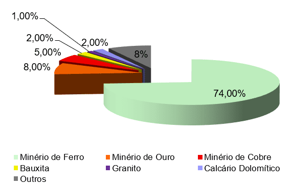
Brazil exports tons of ores, represented in Figure 1 (graph) between the years 2020/2021, there was a considerable increase of 138.7 billion in 2020 for an annual turnover of 249.8 billion reais in the year 2021. In Regarding gold ore in 2020, the export value was 23.2 billion and in 2021 the export rose to 27.1 billion, copper ore from 13.8 billion in 2020 to 17.8 billion in 2021, the bauxite rose from 4.5 billion in 2020 to 5.2 billion in 2021, granite which reached a level of 3.2 billion in 2020 surpassed 4.2 billion in 2021, dolomitic limestone ore which reached 4 .2 billion in 2020, reached 6.2 billion in 2021 and other ores that reached around 21.4 billion in 2020, reached the annual export value of 28.9 billion in 2021 (GEOSCAN, 2021).
FIGURE 1 – Mining production in Brazil
Even though the value data for the Gross Domestic Product – GDP are representative for growth in terms of the national economy, the mining activity generates major environmental impacts. According to the Resolution of the National Environment Council – CONAMA (1986) mining activity requires environmental licensing and in cases of impact on the areas, with transformation of natural and environmental conditions, the law determines the imperative for the polluting company to define the ways recovery of the mining activity enterprise (ARAÚJO, 2017).
Thus, the mining activity not only implies environmental licensing, but also the application of an Environmental Impact Study – EIA and preparation of an Environmental Impact Report – RIMA.
In this regard, there are major challenges in terms of environmental management in mining companies that imply planning actions to analyze the limits of the pits and processing regions and also having a plan to reduce environmental impacts after the activities are carried out (CUBAS and TAVEIRA, 2021).
The use of geoprocessing as resources to avoid environmental impacts in areas exploited by mining is a reality among companies in the sector. So that the application of geoprocessing tools and Geographic Information System (GIS), specialists can obtain results in terms of reconstitution of the previous relief, even after the modification of the landscape, the technique is characterized by the creation of a digital model of the area explored with software tools that simulate a virtual reality in a static way, following directly all the changes presented in the environment, from the evolution of the pit that is later filled to recover the landscape.
With the geoprocessing tools it is possible to obtain a real view of the differences in volumes of the explored areas, with the use of three-dimensional images it becomes possible to recover the landscape with piles of sterile material to fill the pits left by the exploration of the area.
The Geographic Information System (GIS), associated with mathematical modeling on the ground, constitutes a technique of great added value, insofar as it favors the manipulation and analysis of different types of important data: such as punctual data that locate cities and attributes in mining areas; linear data that demonstrate the presentation of rivers and drainage networks and other types of data that can give characteristics to a certain region that can be represented in the form of images, graphs, descriptive information that contemplate detailed variables of the area of operation (LANG; BLASCHKE , 2019).
Geoprocessing tools are also capable of analyzing a region from aspects related to temperature variation, applying different colors to demonstrate the highest or hottest temperatures, such as areas where there is a predominance of concrete (ARAÚJO, 2017).
The use of digital modeling is part of the technology applied during the manipulation process of the Geographic Information System (GIS), when they involve aspects such as data processing and analysis of results, as well as the representation to be explored according to the characteristics of geographic area.
3. CONCLUSION
From the perspective of the following guiding question: What is the contribution of geoprocessing to mining companies in terms of commercial exploration and environmental recovery of areas degraded by mining activities? This article aimed to identify the application of geoprocessing tools in mining activities.
The study made it possible to verify the contribution of geoprocessing to mining companies in terms of commercial exploitation and environmental recovery of areas degraded by mining activities and to identify the application of geoprocessing tools in mining activities, showing that all mapping, images and diagramming tools that are carried out in areas intended for mining, mineral prospecting and evaluation of mineral deposits, are unquestionable as to their ability to produce satisfactory results.
Geoprocessing and its tools allow the creation of the Geographic Information System – GIS, which is based on the dissemination of information in data sources that can be interpreted in different ways and analysis instruments, which favors companies in terms of economic, social, political and environmental.
The tools used in geoprocessing are diversified and technological, which favor a range of actions indispensable to the production of knowledge about the environment, helping in environmental preservation policies and recovery of degraded areas.
It was found that the application of geoprocessing in Brazilian mining contributes to optimizing management through information, research and mineral prospecting, discovery of mineral deposits, planning of exploration of mineral deposits, evaluation and determination of economic advantages, interpretation of mining areas, landscape simulations that help in the evaluation of before and after exploration with a view to the recovery of degraded environments.
The contribution of geoprocessing in reducing the environmental impacts of mining activity is a reality that many mining companies are already striving to determine as a measure to mitigate impacts on mineral exploration. Remote sensing, combined with the use of cartographic data, allows for previous surveys of information related to the area to be surveyed.
In this way, fieldwork becomes more objective and efficient using landscape simulation tools with different systems of orbital sensors, selected according to the objective pursued by the tests performed and the use of georeferenced images for the purpose of comparing the before and after mineral exploration, in order to analyze changes or impacts on the landscape and its characteristics.
The georeferenced images favor a broad view of the landscape before and after exploration, the necessary resources are data sources that allow the expert user a macro assessment to diagnose and quantify losses and damages in events related to environmental degradation.
The georeferenced images can be used in several stages together with other technical data that can produce levels of environmental assessment so that techniques are applied in the pits to leave the landscape undisfigured by the degradation caused by the removal of ores.
REFERENCES
ARAÚJO, Marcelo Henrique Siqueira de. Fundamentos de Geoprocessamento aplicados à Mineração. 2017. 58 f. Trabalho de Conclusão de Curso – Universidade Federal do Recôncavo da Bahia – UFRB, Cruz das Almas, BA, 2017.
CÂMARA, Gilberto; DAVIS, Clodoveu; MONTEIRO, Antônio Miguel Vieira. Introdução a ciência da Geoinformação. 2008. Disponível em: <http://www.dpi.inpe.br//gilberto/livro/introd/>. Acesso em: 13 mar. 2022.
GEOSCAN – Empresa Mineradora. Mineração no Brasil em 2021: Confira um panorama do setor. Disponível em: <https://www.geoscan.com.br/blog/mineracao-no-brasil-em-2021/#:~:text=Os%205%20estados%20acima%20foram,2%25%20e%20outros%207%25%3B>. Acesso em: 12 mar. 2022.
LANG, Stefan; BLASCHKE, Thomas. Análise da paisagem com SIG. 6. ed. São Paulo: Oficina de Textos, 2019.
RIBEIRO, Adalgisa. Geoprocessamento e mapeamento geológico, 2020. Disponível em: <https://adalgisaribeiro.com.br/servicos/mineracao/geoprocessamento-mapeamento-geologico/>. Acesso em: 12 mar. 2022.
ROCHA, Valéria da. Utilização do Geoprocessamento para simular reconstituição do relevo após atividades de mineração. 2011. 47 f. Monografia (Curso de Especialização em Geoprocessamento) – Universidade Federal de Minas Gerais – UFMG, Belo Horizonte, 2011.
SILVA, Luan Patrick dos Santos. Diagnóstico ambiental preliminar de áreas de mineração de saibro no município de Macapá-AP, com o suporte de ferramentas de geotecnologias
. 2013. 50 f. Monografia (Graduação em Ciências Ambientais) – Universidade Federal do Amapá – UNIFAP, Macapá, 2013.
TAVEIRA, Bruna Daniela de Araújo; CUBAS, Monyra Guttervill. Geoprocessamento: Fundamentos e técnicas. 1. ed. São Paulo: InterSaberes, 2021.
[1] Postgraduate in Auditing, Management and Environmental Expertise, Postgraduate in Occupational Safety Engineering, Specialist in Mineral Resources – Mining Engineer. ORCID: 0000-0003-0973-939X.
Sent: April, 2021.
Approved: June, 2022.