ORIGINAL ARTICLE
ARAÚJO, Yan Santana [1], SILVA, Welisson Gomes da [2], SILVA, Wellington Cesar Teles da [3], VASCONCELOS, Maycon Mickael Ribeiro [4]
ARAÚJO, Yan Santana. Et al. Verification of the recurring impacts in the Mutuca Stream, exclusive stretch in Gurupi-TO. Revista Científica Multidisciplinar Núcleo do Conhecimento. Year 05, Ed. 05, Vol. 05, pp. 05-20. May 2020. ISSN: 2448-0959, Access link: https://www.nucleodoconhecimento.com.br/civil-engineering/recurring-impacts
SUMMARY
The objectives of this article were to diagnose the recurrent impacts in the Mutuca stream in Gurupi-TO. Perform the check of the riparian forest area of a unique stretch. The verification of these concepts for data information happened visually, after an analysis of the problems found in the analyzed excerpt. The methodology was based on bibliographic references of the theme for theoretical basis, visits and records of information collected on site. According to the information collections, complementary information was collected to characterize the project of recomposition of the riparian forest along the stream stretch. The problems found indicate that the causes are mainly associated with disorderly occupation on the margin of the stream, absence of riparian forest on its banks, causing signs of erosive processes, family subsistence agriculture on its shores and inadequate disposal of solid waste.
Keywords: Erosive processes, problems, disordered occupation, riparian forest.
INTRODUCTION
Currently, with the development and growth of cities in a disorderly manner without any environmental or urban planning, it causes not only problems caused by housing in prohibited areas such as: on the banks of streams and rivers, slopes, hills, but also storm-making and silting.
The application of natural resources in recent years has been the target of strong burdens and inquiries on the part of environmentalists and the people themselves, in which there is a lot of refuted about the ecosystem precaution and recovery of areas that are in actions of deterioration due to the high socioeconomic growth, consecutive to the progress of the industrial and agricultural sectors as a team with the expansion of the population in the world , has significantly increased consumption by such resources, and this demand is greater than the exchange capacity (RUFINO et. al., 2008).
Erosion is a natural process, but with human activities on its shores can increase and cause significant damage to a stream, that is, it can be damage caused by the actions of rain, removing the material (soil) that encompasses the margins and bottom of the stream. But human action ends up influencing more, due to the deforestation of the riparian forest, leaving the soil unprotected, (RUFINO et. al., 2008).
Siltation, due to the removal of the riparian forest, intensifies the accumulation of sediments (sand, rock, earth), garbage and other materials loaded to the bed of watercourses, whether through the action of wind, fluvial or human beings. In some cases, it may cause extinction as a result of this problem, (CARNEIRO; FARIA, 2005).
Because most of the time population growth grows in a disorderly manner, without any urban or environmental planning, which is visible by inadequate occupation of colonized areas on river banks, hills, cliffs, among others, (CARNEIRO; FARIA, 2005).
With the lack of efficient housing planning, the occupation of land in areas of risk, as well as worrying with regard to safety, brings harm to the environment that also loses by the removal of riparian forest where the Permanent Protection Areas (APP) should exist. Due to these factors, serious consequences arise over time, causing harm to nature and consequently to society, (CARNEIRO; FARIA, 2005).
The Forest Code – Law 4771/65 | Law No. 4,771 of September 15, 1965 aims to highlight all these problems and present solutions aimed at minimizing damage to the environment, which establishes norms on where and how native vegetation of the Brazilian territory can be exploited. The code establishes two types of areas: The Legal Reserve and the Permanent Preservation Area.
Thus, the aim of this study is to understand how to conserve the Permanent Preservation Areas, where people are occupied in undue places.
The Mutuca Stream is located in the city of Gurupi, in the State of Tocantins, Brazil, is the main watercourse of the city. It originates in the Daniela Residential Sector and streams into the Água Franca stream, in the Jardim Primavera Sector. (SALERA JUNÍOR, 2008).
The role of the stream has great influence for the city of Gurupi, mainly because of the construction around it, a park that serves for the leisure of the city. Benefiting about 85,000 people and even the quality of the city, but with the population growth the Mutuca stream has suffered a lot from pollution and reality has been changing the view of the stream. During its banks are found building materials, rubble, even the deforestation of the riparian forest, constructions in areas of APP. It is one of the main drainage systems of the city, that is, in times of abundant rainfall, all rainwater dumped in the city is captained by drainage and destined to the Mutuca stream, consequently leading to a large tributary of the river.
In the presence of the above, this article had as reference, where on-site visits were made in order to determine the main impacts on the Mutuca stream.
1. LITERATURE REVIEW
The Permanent Preservation Areas were instituted by the Forest Code (Law No. 12,651, of May 25, 2012), which refers to legally protected, environmentally fragile and vulnerable territorial spaces, being public or private, urban or rural, covered or not by native vegetation.
The APP is an area that must be preserved by its characteristic and importance. Importance in the preservation of certain ecosystems, in the non-occurrence of environmental disasters, for example: in the watercourses, hilltop, mangroves, dunes that are areas of extreme importance for our country. Many cities are cut by rivers and the watercourse, where they are called Urban Permanent Preservation Areas that must also be preserved. The preservation of them and the margins results for future generations a healthier environment with fewer impacts such as floods, landslides and others.
Such areas in the urban environment value the landscape and natural heritage offering leisure and recreation areas, providing greater quality of life to the population. Hence the need for its maintenance as a way of continuing its function. The lack of planning in the urbanization process results in irregular occupation and misuse of these areas, reducing and degrading them more and more, causing serious problems in cities. This slowing process of growth requires a strong commitment to the increase and improvement of urban environmental policies aimed at the recovery, maintenance, monitoring and supervision of APP in cities.
Riplet forests are the fundamental factor in preserving the environment around watercourses. It is the native vegetation located on the banks of rivers and stream, lakes, springs and dam. With the suggestive name, “ciliary” is given for being surrounding the waters, and being as important for your conversation as are the eyelashes for our eyes, because it has the important function of maintaining water quality, regularization of hydrological cycles, biodiversity conservation and soil instability.
In its important function the riplet forests, preserves the quality of water reducing the silting and the force of water that reaches rivers, lakes and dams preventing the entry of pollutants into the water environment. They also contribute through vegetation to biodiversity conservation, as it provides food and shelter for wildlife. It is important to inform that ripiary forests are present in all biomes: Atlantic forest, serrado, Amazon forests, caatinga, pantanal and pampa.
The Brazilian forest code determines a minimum distance to be maintaining from the riparian forest on the banks of a river, called permanent preservation areas.
This article was carried out in the Mutuca stream, located in the municipality of Gurupi-TO, where it is part of the Formoso River basin, where it encompasses part of the state with 21 (twenty-one) municipalities, where they add outstanding percentages of exposure in real possession and each sub-basin. Gurupi has a dominantly tropical climate in the months of late August to the end of April, with 9 months of rain, the rest is a dry winter where temperatures are compensated and average annual temperatures fall slowly, relating to the elevation of altitude. In winter temperatures turn from 19° to 39°, with lows of up to 17°, with an average annual precipitation of the state is about 1500 mm to 1600 mm. In times of drought it is common for the city to suffer from bushfires, little humidity and a very stuffy climate.
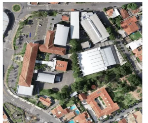
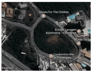
Figure 1.1: Excerpt used to carry out the study, the red line represents the Mutuca stream (GOOGLE EARTH, 2020)
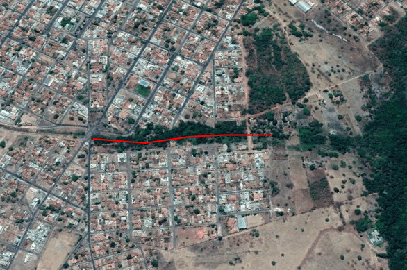
Excerpt used for the purposes of studies of this article, and the extension of the stream is covered by more areas of the city, having the main leisure area of the city (Parque Mutuca), where it did not enter the study of this material.
2. CASE STUDY
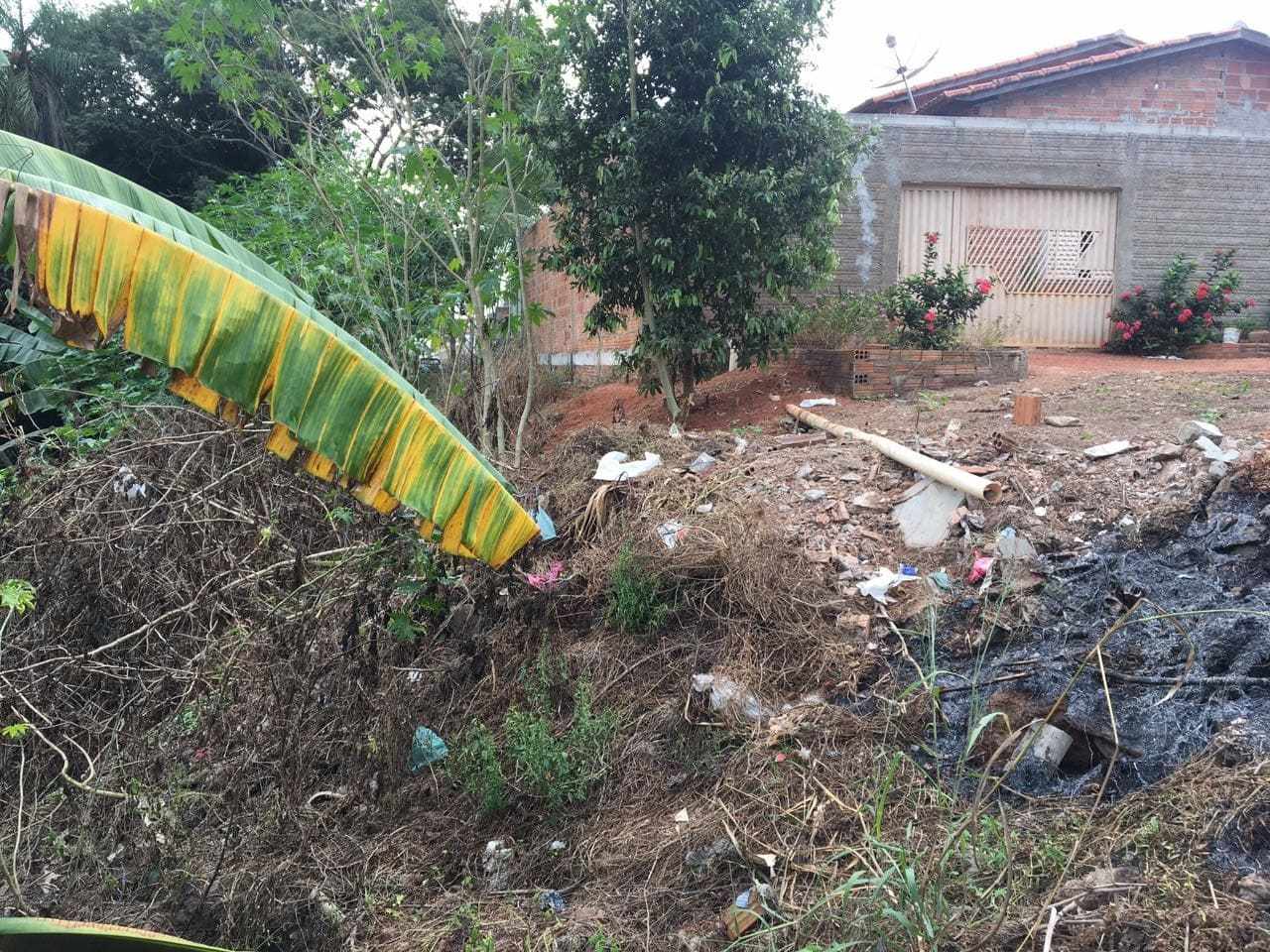
With the accelerated advance of urban areas, buildings take undue spaces occupying territories that should be preserved by the Law that governs the environment. Rivers, streams and springs are being degraded, because with the intense invasion of these areas there are problems such as accumulation of solid debris, constructions in the areas of APP and disappearance of the riparian forest.
The previous study was conducted in Gurupi-TO, where it was carried out in a stretch in the Mutuca stream, which is the most important watercourse in the city. It has its source located in the Daniela sector and its mouth is in the primavera garden sector, where it flows into the Água Franca stream. A park was built in a stretch higher than the studied, where it is of great importance to the population and also brought the contribution to the enrichment of the beauty of the city.
On-site visits were made and recorded through studies and photos, where the advance of the disordered occupation of the population around the stream was observed, in view of the growing population within the areas of the Mutuca stream. Later, many problems were observed mainly due to the lack of riparian forest in the margins, with the development of erosive problems and family subsistence agriculture in the studied stretch on the margins and improper accommodation of solid sediments (Figure 2.1).
Figure 2.1: Graph of the most relevant impacts observed in the Mutuca stream.
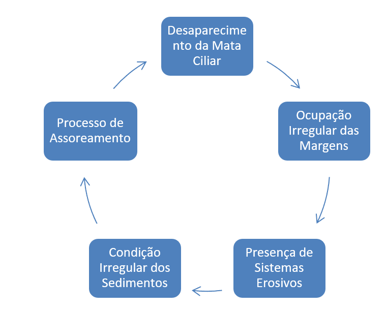
As observed in Figure 2.1, it was verified that the disordered accommodation of the population on the banks of the stream, mirroring the influence of the occupation towards the bed of the same. It can be observed, in view of the problems mentioned in Figure 2.1, that due to the lack of riparian forest on the banks of the Mutuca stream, signs of erosive processes and family farming significant for the study area were caused, where in addition there was a lack of sanitation and disposal of solid sediments around its margins.
Due to the advance of irregular occupation along the Mutuca stream by the urban population, as seen in Figure 2.2, this is an adversity that happens on a large scale, then shown in several studies (GALVAN et al., 2006; PINTO et al., 2009).
Figure 2.2: Irregular occupation in the permanent preservation area (APP) of the Mutuca stream.
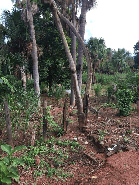
Given the problems, the most important points have extreme links to the deforestation of the riparian forest (figure 2.3). The lack of it on the banks of the Mutuca stream is strongly marked by the misuse of the soil by diversified agricultural activities, the change of native vegetation by the pasture and also, but not least, family farming, where several plantations were observed in the stretch.
With the interest of seeking knowledge for the importance of riparian forest in the wrap of these regions considered areas of environmental preservation, and important to maintain the original course of the stream itself, even the quality of the water, with the advance of deforestation of it, it was possible to observe the effect that the lack of riparian forest prove in the situation experienced in the stream , showing the importance of it (DONADIO et al., 2005). Agreeing with (BAILLY et al., 2012), in which he mentions that the main environmental problem in the Ponte stream in Iguatemi-MS was the lack of riparian forest.
Figure 2.3: Lack of riparian forest on the banks of the Mutuca stream.
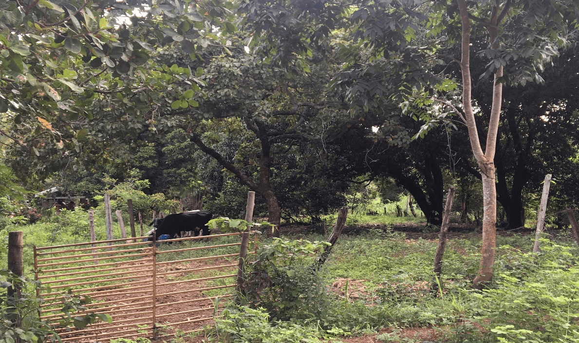
It was noticed the existence of animals during the research, causing instant problems, since with the degradation of the animals around the banks of the stream, the erosive process of the stretch is accelerated, collaborating with the recommendations made by TORRES et al., 2007, in which erosive systems in the form of small butchers are caused by the sharp degrading of cattle in the areas of APP, as can be seen in Figure 2.4.
Figure 2.4: Animals within the stream preservation area.
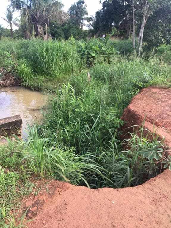
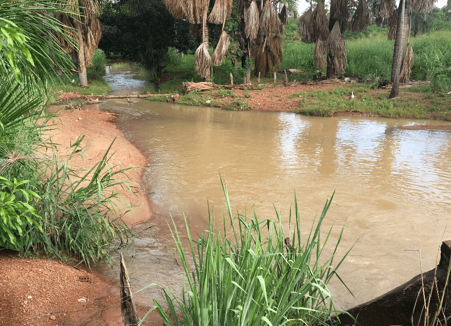
Another attack in the Mutuca stream was the erosive process found in some places of the stream, as shown in Figure 2.5, it shows the progress of this process that is called gullies, in which they are due to the unprotection of the soil (riparian forest), causing the advanced stages of erosions, exposing themselves in the future to unrecoverable cases of the soil. With this degradation of the soil, where these advanced cases are found, it is possible to lose the production capacity of the soil, that is, it destroys arable land and still contributes to the silting of rivers.
Figure 2.5: Erosive systems present in the Mutuca stream APP.
A piece of the stretch studied in this article, was a place where there is a bridge where the stream is crossed. The bridge that is located in the Primavera sector (figure 2.6), in times of abundant rainfall, the stream receives much of the drainage of half the city, that is, the bridge does not support the flow in floods and with this has suffered pathologies such as erosões (figure 2.8) and consequently causing silting from the bridge landfill, illustrated in figure 2.9, during the course of the river.
Figure 2.6: Bridge over the Mutuca stream in the Spring sector.
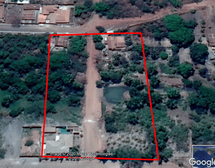
Figure 2.7: Mutuca park in times of great precipitation.
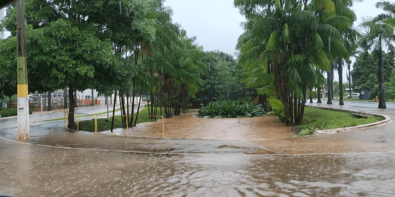
As seen in Figure 2.7, in times of many precipitations the Mutuca Park suffers a lot from flooding, even overflowing and hindering the transfer of cars on the side roads of the park.
Figure 2.8: Erosion of the embankment on the bridge over the Mutuca stream in the Primavera sector.
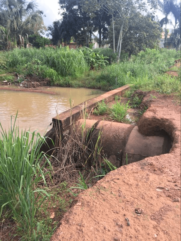
Figure 2.9: Silting up the stream in the Spring sector.
It is possible to notice that the watercourse of the stream, in the stretch (Primavera sector), was affected by silting, which results in excess material on its bed and hinders its use. Figure 2.9 shows the landfill gravel on the banks of it, this happens in times of abundant rainfall, the soil is washed and its surface layer is removed, and the sediments (soil and rock particles) are transported by runoff in the direction of the stream, where they are deposited. It is important to know that this is a natural process, but with the human actions (removal from the riparian forest) in the preservation areas along the stream, it ends up intensifying even more. With this a greater amount is deposited at the bottom of the stream and on the margins.
In the studied part, it was not recognized whether it wants any action or determination of restoration of the riparian forest, even the “blockade” of the exclusive areas of APP, so that it would prevent the advance of irregular constructions on the site and the entry of animals (cattle, chicken, etc.).
As the reduction of permanent preservation areas, in the studied stretch, shows that the more the degradation of this natural vegetation advances, the more the stream over with the environmental degradation and destruction of its natural ecosystem, which causes a significant decrease in its flow that is part of the landscape of the (APP) of the Mutuca stream. In view of all these problems, it is essential to recover the native vegetation of the place. But the problem is in finding economic, ecological, cultural means that encourage the recovery of the natural coverage of the site, due to the existing occupations on the site and family farming.
Consequently, it is essential that some project related to the restoration of the vegetation cover of the Mutuca stream be elaborated, in order to avoid even greater disorders for the local population of the analyzed stretch. Knowledge about local ecosystems becomes indispensable at this time, because recomposition must happen with species determined by climate, relief, among others. At the site it was possible to observe that there were no procedures that try to minimize the problems highlighted and should take initiatives consistent with the facts observed in the area of preservation of the Mutuca stream.
La fuente (arroyo Mutuca) estudiada es de suma importancia para la población de Gurupi, debido al parque Mutuca (principal fuente de esparcimiento de la ciudad) e incluso el drenaje de parte de la ciudad está destinado para el recorrido. Por lo anterior, no se ha tomado ninguna iniciativa para evitar la constante devaluación del lecho y del curso de agua, que ha ido creciendo a lo largo de los años. Estas ocupaciones irregulares en las áreas de APP están relacionadas con varias ubicaciones en Brasil y también relacionadas con diversas obras y artículos.
Riplet forests have numerous functions, being one of the main objectives of soil protection against the actions of water systems in the environment, protecting against erosion. Taking this into account, it is important to obtain preventive and restorative measures against these impacts, especially in encouraging the education of the population due to the protection of these areas.
3. DISCUSSIONS
The problems observed in the Mutuca stream are relevant, in the stretch of work (Primavera sector) it was possible to relate the accommodation of solid debris, irregular appropriation of land in the areas of APP, absence of riparian forest in various parts of the analyzed stretch, improper occupation of animals in places where there should be the existence of riparian forest, advanced presence of erosive processes in its margins , silting the bed, among others significant in these, being similar to the effects seen by the author Ribeiro (2013).
Based on the literature of Silva and Nobrega (2007), the degradation of the area around the stream suffers greatly, because it is possible to perceive humanistic dismay, which should promote actions to avoid disorderly occupation and constructions in prohibited areas. With this, this problem ends up being considered irrelevant, in case of heavy rainfall, the soil without its natural protection is taken to the stream and thus, silting the watercourse.
According to the author Júnior (2008), the stretch needs serious repairs on its banks, the most important is respect for the areas of APP, so that there can be a recomposition of the riparian forest on site. But this should be a detailed analysis of the location, that is, socioeconomic, environmental, among others, that can agree and thus, the procedures are performed.
4. FINAL CONSIDERATIONS
It should be taken due importance of this spring to the city of Gurupi taking into account in the execution of this project, because it is essentially connected with the leisure and quality of life of gurupiensecitizens, where above the analyzed stretch there is a laser park that bears the name of the stream (Mutuca Park), but even having the due importance the disregard is still constant and has been increasing over the years , suffering from actions carried out by man and even natural. A degradation of the vegetation was observed in relation to the required preservation area, showing the need for the recomposition and preservation of the natural riparian forest of the stream.
Given the above, it is possible to perceive the abundance of positive effects of the importance of riparian forest for this stream, so it is necessary that they enable a project to restructure the riparian forest, elaboration of preservation measures and procedures to raise awareness of the population. Therefore, measures to prevent and restructure the riparian forest are extremely important, so that they reduce the impacts resulting in the Mutuca stream in the Primavera sector.
REFERENCES
CARNEIRO, P. A. S.; FARIA, A. L. Ocupação de encostas e legislação urbanística de Viçosa-MG. Revista Caminhos da Geografia, v. 6, n. 14, p. 121-138, 2005.
CORREIA, Alessandra Martins; DOS SANTOS, Moacir José. ANÁLISE DOS BENEFÍCIOS DA PROPOSIÇÃO DE UNIDADE DE CONSERVAÇÃO MUNICIPAL EM GURUPI-TO: O ICMS ECOLÓGICO COMO INSTRUMENTO DE POLÍTICA AMBIENTAL. REVISTA CEREUS, v. 9, n. 1, p. 37-65, 2017.
DE OLIVEIRA, Alessandro Lemos; DE SOUZA, Patrícia Aparecida; CUNHA, Bianca Pietsch. RECUPERAÇÃO PARA A NASCENTE DO CÓRREGO MUTUCA EM GURUPI–TO.
DE SOUZA FERREIRA, Rômullo Quirino, et al. “Diagnóstico ambiental do córrego Mutuca, Gurupi, TO.” Revista Verde de Agroecologia e Desenvolvimento Sustentável 10.4 (2015): 18.
DONADIO, N. M. M.; GALBIATTI, J. A.; PAULA, R. C. Qualidade da água de nascentes com diferentes usos do solo na bacia hidrográfica do córrego Rico, São Paulo, Brasil. Revista de Engenharia Agrícola, v. 24, n. 1, p. 115-125, 2005.
GOOGLE EARTH. Imagens do córrego Mutuca. Gurupi – TO: Google Earth, 2019. Disponível em: <http//www.google.com.br/googleearth >. Acesso em: 20 fev. 2020.
HOLZBACH, Juliana Cristina et al. Análise da água do córrego Mutuca de Gurupi-TO. DESAFIOS-Revista Interdisciplinar da Universidade Federal do Tocantins, v. 6, n. 4, p. 23-31, 2019.
PEREIRA, Priscila Pini et al. Caracterização física do córrego Mandacaru, Maringá–PR. UNOPAR Científica Ciências Exatas e Tecnológicas, v. 13, n. 1, 2014.
PINTO, I. C.; SOUZA, R. G. N. de.; LANDI, M. O.; CARVALHO NETO, P. R. E. de.; REIS, F. A. G. V.; GIORDANO, L. do C. Avaliação ambiental dos impactos causados pela ocupação urbana em Áreas de Preservação Permanente do córrego Olinda, no bairro Jardim das Flores, em Rio Claro (SP). Revista Engenharia Ambiental, v. 6, n. 2, p. 580- 593, 2009.
RIBEIRO, Horrana Ferreira. Caracterização das APP’S dos córregos inseridos no perímetro urbano da cidade de Gurupi-TO. In: 9º Seminário de Iniciação Científica da UFT, v. 5, 2013. 2013.
RUFINO, A. C. S.; FARIAS, M. S. S.; DANTAS NETO, J. Avaliação qualitativa da degradação ambiental provocada pela mineração de areia – região do médio curso do rio Paraíba. Revista Engenharia Ambiental, v. 5, n. 1, p. 47-64, 2008.
SALERA JÚNIOR, G. Recursos Hídricos de Gurupi. 2008. Dissertação (Mestrado em Ciências do Ambiente) Universidade Federal do Tocantins/UFT, Palmas, 2008.
SANTOS, Marcos Giongo; BARBOSA¹, Lívia Nayanne Lemos. Avaliação ambiental e indicação de medidas mitigadoras para a nascente do córrego mutuca, Gurupi-TO. 2015
VIEIRA, W. C. Estudo das feições erosivas na microbacia do córrego Boa Vista, Prata/MG. 2006. 61 f. Dissertation (Master’s degree in Geography) – Federal University of Uberlândia, Uberlândia, [1]2006
Civil Engineering Student.
[2] Civil Engineering Student.
[3] Specialization in progress in MBA in design, dimensioning and structure modeling. Specialization in MBA in budgeting, planning and control in civil construction. Graduation in Civil Engineering.
[4] Civil Engineering Student.
Sent: April, 2020.
Approved: May, 2020.