GUERREIRO, Eginaldo Alves [1]
LÍCIO, Fernando Gama [2]
TEODORO, Roberto Leal [3]
ALMEIDA, Patrícia [4]
GUERREIRO, Eginaldo Alves; et.al. Study of the Drainage System for Transposition of Talvegue by Bueiros in BR-324 / BA, in the Porto Seco Pirajá Region. Multidisciplinary Scientific Journal. Edition 08. Year 02, Vol. 01. pp. 73-87, November 2017. ISSN:2448-0959
SUMMARY
In the last decades the disordered occupation in the region of Porto Seco Pirajá, in Salvador – BA has compromised the drainage system of the section of the BR-324 that cuts the neighborhood, through the waterproofing of the ground. In this context, the present work presents a case study of the transposition of talvegue located on Highway BR-324 / BA at the time of KM 619 + 450, whose watershed of approximately 100ha underwent some changes in its physical characteristics due to waterproofing, modifying the flow of water of the talvegue. After hydrological studies the solution adopted was a 1.8m diameter culvert, and a second culvert was also designed to be implanted as the volume of rain increased. Through this study it is possible to have a better understanding of the process of hydraulic sizing and implantation of sewers.
Key words: Transposition of Talvegue, Bueiro, Hydrological Studies.
1. INTRODUCTION
The accelerated growth of the urban population, together with the lack of housing policies, has led to an increase in the use and disordered occupation of the land. These changes modify the natural conditions of soil infiltration, increasing the sealing and the flow velocity of the rainwater, reducing the time of concentration in the river basin (SANTOS, 2017).
Faced with this problem, the importance of designing drainage devices capable of draining the entire flow of rainwater arises. For this, it is necessary to develop a hydrological study with the purpose of collecting information to determine the project flows and through a drainage system to ensure the safety of the body, the environment and users (JABÔR, 2017).
According to Jabôr (2017), these hydrological studies consist in the collection of data and information that allow the climatic and geomorphological characterization of the basin. For example, cartographic information for morphometric characterization, analysis of pluviometric data to define the model of representative rainfall, or even on-site visits in order to obtain information from residents on the way of water, floods and other relevant occurrences.
Once the studies have been carried out, the drainage projects should be started, the type of solution to be adopted in the transposition of talvege, which is the case under study, depends on many factors, among them it is possible to highlight the possibility of execution. In the case of major highways under normal operating conditions the destructive execution of drainage devices become very costly. In this case, a non-destructive method can be adopted for the execution of the transposition, which consists of the construction or recovery of underground structures with minimum road rupture and less influence on the road system.
In the present case, the hydrographic basin located near the Porto Seco Pirajá neighborhood in Salvador presents rainwater flows much larger than the capacity of most of the installed sewers, resulting in widespread flooding in low areas during periods of heavy rains. Comparing the basin in 1976 and today, occupation of the areas surrounding the BR-324 highway grew and the large areas of flood arrests that existed were grounded for deployment of multiple commercial ventures.
In this context, the objective of this study is to characterize the existing drainage problem, through the analysis of the culverts that currently carry out the transposition of the talvegue on the highway; to present the main contributions of the hydrological study in determining the flow rates used in the design of additional devices made by the BR-324 concessionaire. In addition, show the implementation of drainage solutions adopted.
2. LITERATURE REVIEW
According to Jabôr (2017), drainage is the science that aims to remove or prevent the excess of surface and deep waters through an efficient Drainage System, thus making the protection of the region. The Highway Drainage System consists of a list of devices such as:
- Current works of art;
- Special works of art;
- Cutting and landfill protection valves;
- Rock cut protection wall;
- Cutting gutters and landfill;
- Cutting and landfill exits;
- Cutting water outlets;
- Water intakes in landfills / landfills;
- Cutting water and landfills;
- Scatter sills / power dissipators;
- Collecting boxes;
- Landfill gutters;
- Longitudinal deep drain;
- Transverse drain;
- Fishbone drain;
- Mattress drainage;
The drainage of highways has as main function to capture and to lead the water that reaches the estradal body, so that it does not affect the safety and durability of the way. These waters originate from hydrographic basins that through the topography of the terrain are led towards the highway. Therefore, it is necessary to transpose the talvegues that cross the highways through manholes, pontoons or bridges (DNIT, 2016).
The manholes are elements responsible for the passage of the waters longitudinal and perpendicular to the cantilevered bed to the highway, these are composed by body and mouth. The body is located under the cuts and embankments, and the mouths are responsible for capturing the water sent upstream and downstream (DNIT, 2006).
So the sewers can be considered (DER / PR, 2005):
- Greide culverts – devices that collect water from the collection boxes. They are used to transpose water from surface drainage devices.
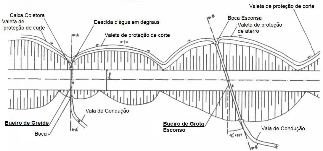
- Bueiros de Grota: They are culverts that are located in the bottom of the talvegues and guarantee the transposition of the flow of water from one side to another of the highway.
Figure 1 presents examples of both types of culverts:
According to the National Department of Road Infrastructure (DNIT), the manholes are classified in four classes:
- As for the shape of the section, they can be tubular (circular section), cellular (rectangular or square section) and special (ellipsoidal or oval).
- As for the number of lines, they can be implanted with single or multiple lines (double or triple).
- As for the materials, they can be of simple concrete, reinforced concrete, corrugated metal sheet or high density polyethylene (HDPE), in addition to glass fiber reinforced plastic (GRP).
- As to the origin, they may be normal, when the culm axis is orthogonal to the axis of the highway; or hides, when the longitudinal axis of the culvert is at a different angle from zero to the normal axis of the highway.
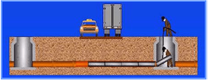
In relation to the constructive process of the culverts, there are two ways of executing them, by the Conventional Method and by the Non Destructive Method. The Non Destructive Method consists of the execution of a culvert installed without need of opening of the body of the embankment, which does not cause disruption to the traffic. This method is indicated on roads with a high volume of traffic, in regions where the landfill is greater than 6.00m, in urban areas for implantation of a rainwater network, among others. (JABÔR, 2017). According to the Brazilian Association of Non Destructive Technology – ABRATT, this method is used in the construction of new networks, in the rehabilitation and recovery of existing networks, where there is no traffic interruption or interference in the work environment.
2. METHODOLOGY
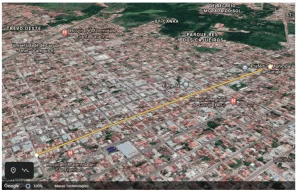
The present work is characterized as a bibliographical research, followed by a case study carried out in a basin of approximately 100ha, as well as in the drainage system of the track that intercepts the basin. The same is BR-324 / BA, highway connecting the cities of Salvador and Feira de Santana, more precisely in the region of Porto Seco-Pirajá KM 619 + 450.
This study aims to present the main results contained in the BR-324 Highway Macrodrenage Diagnosis, provided by the highway concessionaire, focusing on the case of the Porto Seco region in Salvador, where it implemented a macrodrainage system to solve widespread flooding in the low areas in periods of heavy rains.
3. CASE STUDY
The case study was carried out at BR-324 / BA, a Brazilian federal highway that connects the road junction in Feira de Santana to Salvador, the same is also known as Rodovia Engenheiro Vasco Filho.
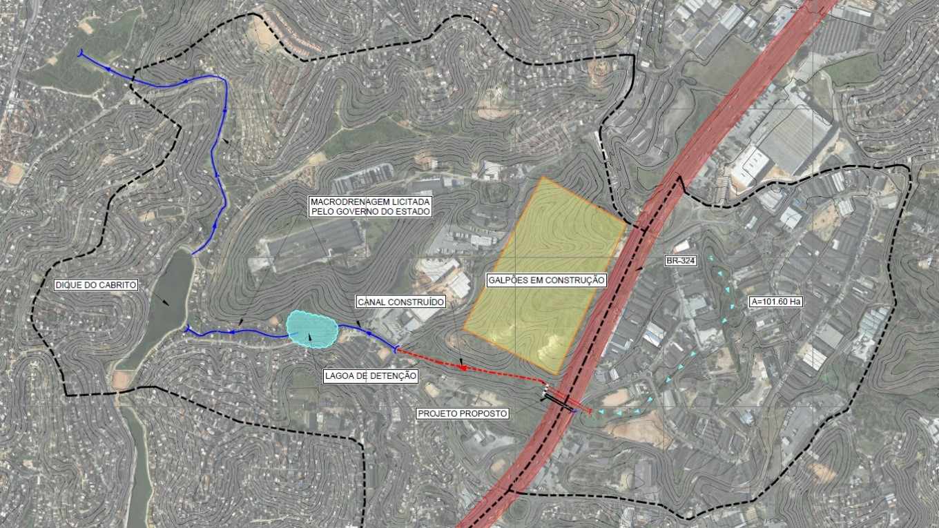
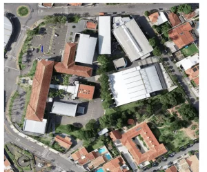
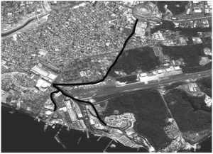
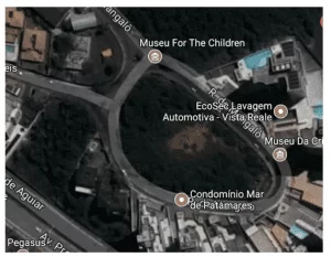
The highway has a drainage system, in the surroundings of km 619 + 450, responsible for draining the waters originating from a hydrographic basin upstream. Figure 3 delimits the basin and the entire course of rainwater up to the launch in the Cobre Cove and the Tainheiros in the Ribeira neighborhood. The cartography was carried out based on SICAR / RMS – Cartographic System of the Metropolitan Region of Salvador (1995).
At the study site, some pipes and galleries were identified in order to drain rainwater, but they were ineffective due to the increase in rainfall volume and the increase in waterproofing of the soil through improper occupation. The current local work of art system consists of:
- Old dual pipe of 600mm, which is the original version of the drainage of the highway in this place. This device has structural problems, which is why it has been disabled;
- Corrugated steel tubing of 2400mm diameter upstream upstream;
- A double pipe with a diameter of 600 mm and a single pipe with a diameter of 900 mm, both executed by non-destructive process of the landfill of the highway and using high density polyethylene (HDPE) pipes, however these drains only aid the drainage of the local, since both were executed in an emergency;
- A gallery downstream 3.10 m wide and 2.60 m high, which follows the flow of waters from the basin.
3.1 HYDROLOGICAL STUDIES
For the determination of the inflow to the culvert, a hydrological study of the basin region was carried out by the VIABAHIA Concessionaire. In which a return period of 25 years and hydrographic basin was considered in the upstream section of the culvert with an area of 101.6 ha. The following shows which items were analyzed.
3.1.1 Concentration Time
For the calculation of the concentration time, characteristics of the main talvegue were analyzed and it was estimated that it would be 30 minutes.
3.1.2 Flow calculation
In the calculation of flow rates the synthetic triangular unit hydrograph (HUST) method was used. Due to the size of the basin, the most important were: the variation of rainfall intensity, the effects of retention and damping along the course, and the infiltration of rainfall from the soil. In the calculations there are three stages, being: definition of the project rain, definition of the excess rain, and transformation for the final hydrograph.
3.1.3 Rain definition
It was defined from the rainfall data extracted from the publication "Intense Rainfall in Brazil", related to the pluviographic station of Salvador. Thus, a rainfall height was obtained for rainfall with a time of recurrence of 25 years and 24 hours of 191.1mm.
3.1.4 Definition of Surplus Rainfall
The SCS method, Soil Conservation Service, described in the Urban Hydrology for Small Watersheds of the United States Department of Agriculture, was used for the calculation of effective precipitation.
3.1.5 Definition of the Definitive Hydrogram from Surplus Rainfall
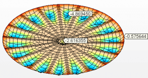
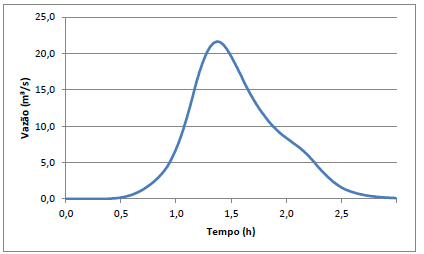
The triangular synthetic unit hydrograph was used to calculate the inflow. Then, the plot of the curvilinear hydrograph was drawn (Graph 1) with the data obtained from the triangular unit hydrograph.
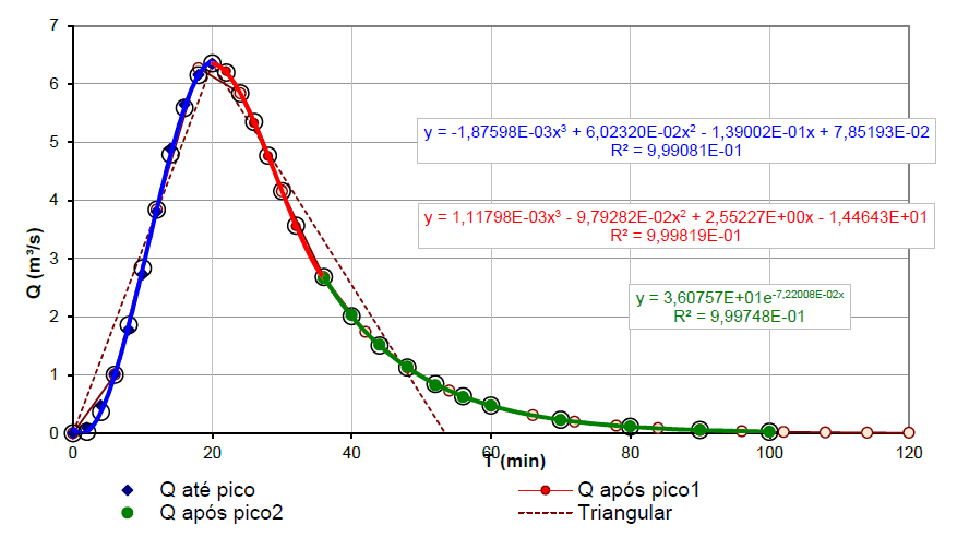
From the data obtained on the effective rainfall and the ordinate data of the curvilinear hydrograph for the time, it is possible to have the hydrographs for different precipitation values effective over time. Thus, with the analysis of this hydrograph, the estimated peak flow rate at 21.6 m³ / s is defined in Graph 2.
Among the assumptions adopted in the design of the drainage solution, no arrests of rainfall were considered in the existing drainage devices. That is to say that the actual flows in the transposition of the talvegue are inferior to those dimensioned, in favor of safety.
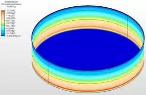
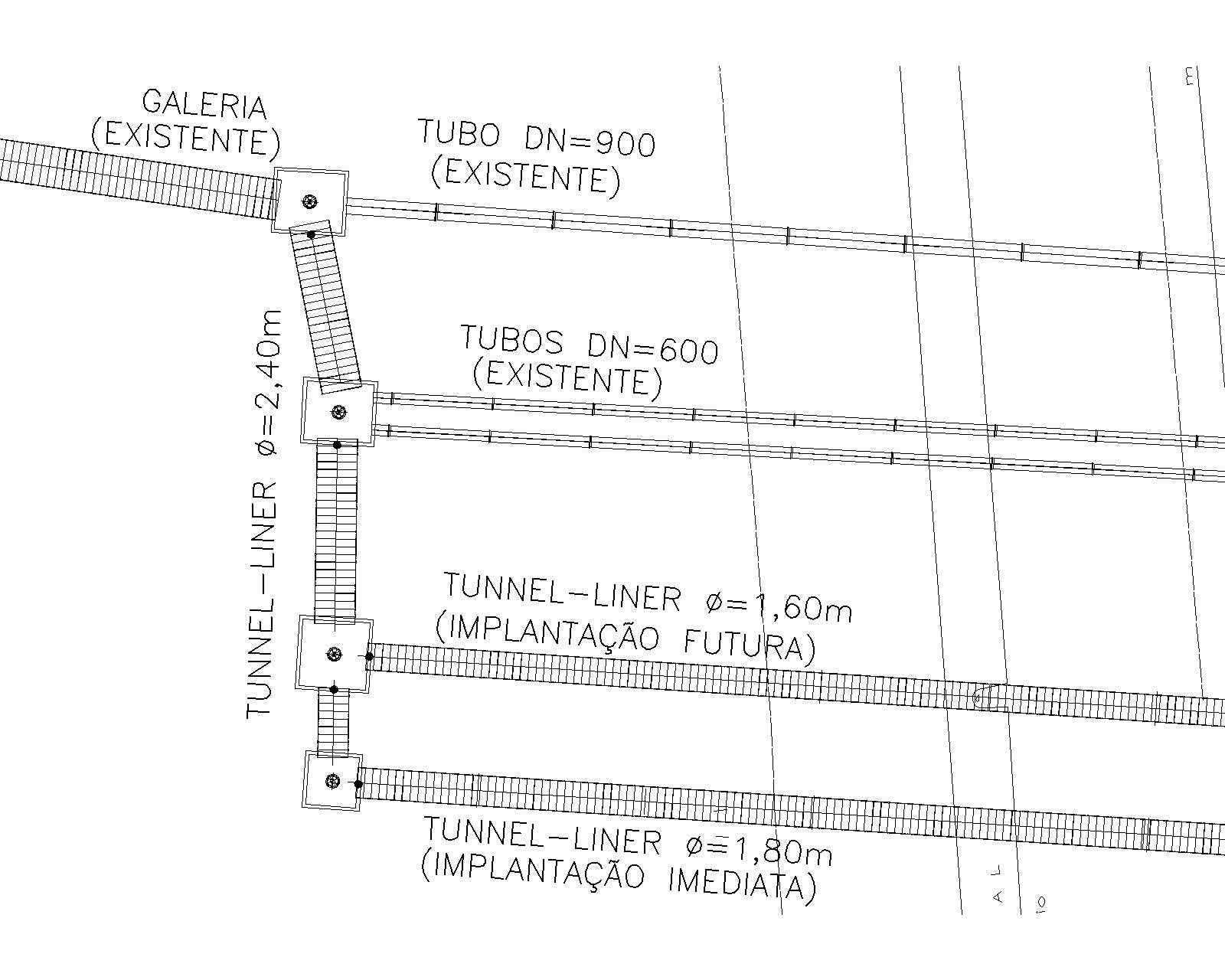
Due to the impossibility of destructive interferences in the highway, the company chose to use two culverts executed by non-destructive method. A culvert with a diameter of 1.8m with longitudinal slope of 0.0093m m, length of 107.64m and thickness of the plate of 3.90mm. And a second manhole with a diameter of 1,6m with similar characteristics to the previous culvert, this being built in a second stage of works, since it was understood that only the construction of the 1.8m diameter line in a first stage already represents a gain the operational conditions of the drainage system under analysis. However, the concessionaire should monitor the results of the flooding processes during periods of heavy rains to evaluate the need to build the second 1.6m diameter line.
Figure 4 shows the layout of the Drainage system composed of existing and projected piping. In the initial stretch, the use of 1,8m diameter piping, compatible with the pipe diameter of the upstream pipe of the immediate stage of works, is foreseen. After the reception box of the 1.6m diameter second-stage wastewater workstation, the pipe diameter passes to 2.4m using the plates purchased by VIABAHIA for the construction of the manhole that would be originally built.
3.2 Implementation of the adopted solution
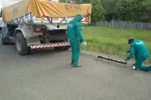
Following are the steps for construction of the immediate phase, the metal tube ARMCO φ = 1,8m.
Firstly, a working well was done using ARMCO φ = 1,8m in order to give access to the employees who started the excavation to install the manhole.
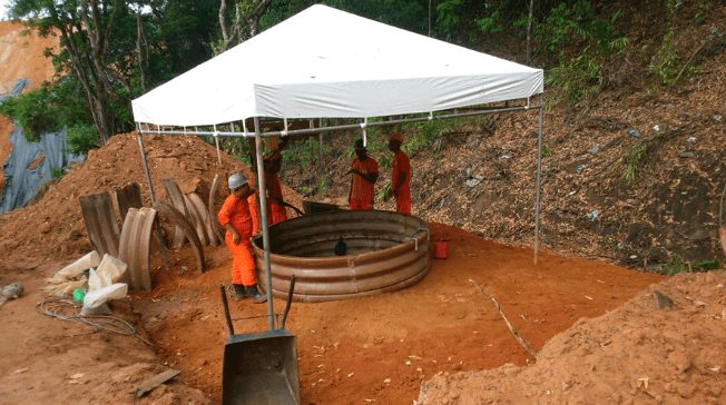
After the work well was leased, the manual excavation with a diameter similar to that of the outer circumference of the HDPE pipe was started. Then the first ring was installed, executed with the injection of mortar filling the voids between the ring plate and the excavated mass.
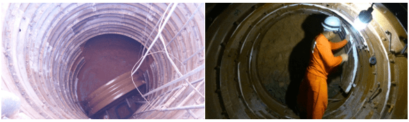
The rings were joined together and distributed along the lateral flanges, where screws and nuts were placed. The plates were mended by bolt-over in the hole, so that the nut was tightened from the inner side.
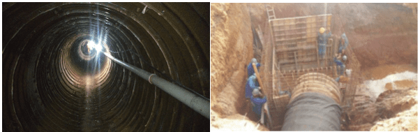
After completing the 107.64m long culverts, the working well was removed and the service fronts were completed.
FINAL CONSIDERATIONS
Through this work it is understood that to carry out an adequate drainage project it is necessary that the hydrological study of the region is first developed. This way it is possible to size the device that best meets the design flow. In addition, the project may provide for capacity increases if the volume of rainfall increases in the future.
In the case under study, a 1.8m diameter line was constructed in a first stage, which represents an expressive gain in the operating conditions of the drainage system under analysis. However, the results of flooding processes should be monitored during periods of heavy rains to evaluate the need to build the second 1.6m diameter line.
This work allowed a better understanding of the process of designing a drainage system, through the case study and the clarification of the steps involved in the implementation of the solution, which in this case was a culvert. Other works can be developed about this basin taking into account other items of the system as galleries or even surface drainage.
REFERENCES
ABRATT. Brazilian Association of Non Destructive Technology. Introduction to non-destructive methods. São Paulo, 2007. Available at: <http://www.abratt.org.br/seminario/intro.pdf>. Accessed on: 10 May 2017.
CONDER (Bahia). SICAR RMS: Cartographic System of Metropolitan Region of Salvador. Salvador: Government of Bahia, 1995.
NATIONAL DEPARTMENT OF TRANSPORT INFRASTRUCTURE. Manual of Drainage of Highways. 2. ed. Rio de Janeiro: DNIT, 2006. 304 p.
DER-DEPARTMENT OF ROADS OF RODAGEM (Paraná). Drainage: Tubular concrete culverts. Curitiba, 2005. 11 p.
DER-DEPARTMENT OF ROADS OF ROAD (São Paulo). Secretary of Transport. Technical Specification: Corrugated Steel Tube Basin. São Paulo: DER / SP, 2006. 11 p.
DNIT- NATIONAL DEPARTMENT OF TRANSPORT INFRASTRUCTURE (Brazil). Ministry of Transport. Manual of Drainage of Highways. 2. ed. Rio de Janeiro: IPR, 2006. 304 p.
JABÔR, Marcos Augusto. Drainage of Highways: Hydrological Studies and Drainage Projects. 14. ed. Ll: Campos Jabôr, 2017. 191 p.
PEREIRA, Djalma Martins et al. Drainage devices for road works: Handout. Curitiba: Federal University of Paraná, 2007. 41 p.
ROSSI, João Fernando. Surface Drainage on Highway SC 390. 2015. 23 f. TCC (Undergraduate) – Civil Engineering Course, University of Planalto Catarinense, Lages, 2015.
SANTOS, Gabriel da Paz. Urban Drainage of the City of Posto da Mata. Multidisciplinary Scientific Journal Núcleo do Conhecimento, v. 13, n. 2, p.181-200, jan. 2017. Monthly. Available at: <https://www.nucleodoconhecimento.com.br/engenharia-ambiental/drenagem-urbana>. Accessed on: 10 May 2017
VIABAHIA. Diagnosis of the Macrodrainage of BR-324 Highway. Salvador: VIABAHIA Concessionária de Rodovias S.A., 2016. 46 p.
VIABAHIA. Hydraulic design of the 619 + 450 kilometer of the highway BR-324. Salvador: VIABAHIA Concessionária de Rodovias S.A., 2016. 19 p.
VIABAHIA. Photo Report: Project as built. Salvador: VIABAHIA Concessionária de Rodovias S.A., 2016. 3p.
United States Department of Agriculture. Urban hydrology for small watersheds. Washington: USDA, 1986.
[1] Civil Engineer, Postgraduate in Road Infrastructure Engineering by the School of Engineering of Surveying
[2] Architect, Postgraduate in Road Infrastructure Engineering by the School of Engineering of Surveying
[3] Civil Engineer, Postgraduate in Road Infrastructure Engineering by the School of Engineering of Surveying
[4] Civil Engineer, Postgraduate in Road Infrastructure Engineering by the School of Engineering of Surveying