ARTIGO ORIGINAL
ASSIS, Matheus Miranda de [1], CUNHA, Marcelo José Pereira da [2]
ASSIS, Matheus Miranda de. CUNHA, Marcelo José Pereira da. Potential for generating Electric Power from heliothermic energy systems in the State of Minas Gerais. Revista Científica Multidisciplinar Núcleo do Conhecimento. Year 05, Ed. 06, Vol. 01, pp. 19-43. June 2020. ISSN: 2448-0959, Access link: https://www.nucleodoconhecimento.com.br/environmental-engineering-en/potential-for-generating
SUMMARY
Given the growing consumption of electricity currently experienced by society, there is an increasing demand in the diversification of the energy matrix using renewable sources. Against this scenario, this paper analyzes and evaluates, with the aid of spatial analysis in geographic information system (GIS) using Quantum Gis and ArcGis applications, the locations most likely to install heliothermal plants in the state of Minas Gerais. A bibliographic review of heliothermal system models was performed, pointing to the central tower model as the most advantageous and efficient in relation to the others. The crossing of normal direct irradiation data provided by the Solar and Wind Energy Resource Assessment (SWERA), cartographic base of the state of Minas Gerais, hydrography and electric power transmission lines, digital elevation model elaborated from the data of the Shuttle Radar Topograpy Mission (SRTM) provided by the United States Geological Survey (USGS) and, finally, the quantitative and spatialization of industries installed by municipality indicated two regions in Uberlândia/MG, as places more likely to install a heliothermal plant in the state.
Keywords: Thermosolar energy, geographic information system, spatial analysis.
1. INTRODUCTION
The economic development of the planet has caused an increasing increase in energy consumption. As there are increasing charges for global warming, there is an increasing need to provide this demand with renewable energy sources, such as wind, solar and biomass (CAMAROS; OLIVEIRA; SHAYANI, 2016).
According to the International Renewable Energy Agency (IRENA, 2017), in 2016, solar energy worldwide increased by 70,873 MWe compared to 2015, representing 13.9% of all energy produced globally among other renewable sources.
Germany, currently Europe’s largest economy, is among the countries that invest the most in the solar energy matrix, and its more sunny region has a radiation index 40% lower than the least sunny region of Brazil (CEPEL, (Electric Energy Research Center) [in between 2013 and 2016]; CABRAL; SENNA; TORRES, 2013).
According to the National Electric Energy Agency (ANEEL, 2017), the Brazilian electric matrix is divided into: hydroelectric (68.1%), biomass (8.2%), wind (5.4%), solar (0.01%), natural gas (9.1%), petroleum products (3.7%), nuclear (2.6%) and coal and derivatives (2.9%). According to Portal Brasil (2017), solar energy increased by 8.4% between November 2015 and 2016, demonstrating the constant progress of the solar source, even with the economic crisis experienced by the current scenario.
Because it is located in a region vicinal to the equatorial line, Brazil presents low variations in solar incidence rates throughout the year, making its territory very prone to the installation of systems that take advantage of solar irradiation as an energy source (SILVA; SOUZA, 2016).
Currently several governments and non-governmental organizations have encouraged the development and use of technologies that promote the greater energy use of solar irradiation. Among the best-known technologies is photovoltaic solar energy, and its operation is based on the conversion of solar irradiation into electricity through semiconductor materials (KEMERICH, 2016).
Another promising technology is heliothermal energy, also called Concentrated Solar Power (CSP). Quite similar to conventional thermoelectric, this model is based on the use of mirrors strategically positioned on the ground that receive and concentrate solar radiation to a central receiver. In this receiver circulates a fluid (air, water, salts or oil) that when heated by radiation reaches high temperatures, promoting an increase in pressure in the system, consequently generating mechanical energy that will later be converted into electric energy (LODI, 2011).
The present work aims to identify the regions of the state of Minas Gerais most prone to the installation of heliothermal systems based on data of normal direct irradiation, slope of the terrain, water availability, proximity to transmission lines and nature conservation areas.
2. THEORETICAL FRAMEWORK
The operation of heliothermal systems follows the basic premise of reflection and concentration of solar rays in central receivers, which have a smaller surface, in order to obtain the highest possible temperature for the full functioning of the system. Currently, four models of heliothermic systems are used, which will be discussed below.
2.1 LINEAR PARABOLIC OR PARABOLIC CYLINDRICAL
Considered the most mature technology among those currently used, it is basically formed by a set of curved mirrors interconnected in parabolic format up to 100 meters long, connected to a single-axis solar radiation tracking system; channels of several parallel columns from North to South. Its reflectors have a diameter of 5 to 6 meters. Commonly, its central heat receiver consists of a vacuum glass tube (to reduce heat losses) with a stainless steel tube inside, applied with a black coating through which it crosses a fluid, such as synthetic oils, which can reach temperatures up to 390°C. The coating applied to the tube presents a high level of absorption of the radiation coefficient and reflectivity of approximately 5% (SILVA, 2013; PHILIBERT et al. 2010).
The oil circulates in a closed circuit and is sent to a exchanger where its thermal energy is used to heat the water and generate steam at high pressures. Then the generated steam feeds a turbine connected to a generator producing electricity. Finally, the steam is routed to condensers that reduce its temperature and return it to the process in a closed loop (SILVA, 2013).
According to Bianchini (2013), the plants of this model of greater capacity currently in operation can generate up to 100 MW of electricity, such as the Shams 1 plant in operation since 2013 in the United Arab Emirates.
2.2 PARABOLIC DISC
Using mirrors in the shape of parabolic discs – also called parabolic dishes – this system reflects the direct radiation received to a central receiver, located at its focal point. Direct radiation heats the central receiver through which a working fluid circulates, which will drive a Stirling cycle mo[3]tor; only then trigger a generator (BIANCHINI, 2013).
According to Kalogirou (2009), the parabolic system can reach temperatures above 1,500°C, reaching the highest temperatures among all systems and can be installed as unit systems or large-scale, being indicated for more isolated regions.
2.3 FRESNEL
The Compact Linear Fresnel Reflector (CLFR) system, also known only as Fresnel, features narrow, long mirrors with a flat or slightly curved surface, arranged in an aligned and segmented manner, displaying characteristics close to the parabolic cylindrical system. This system presents its radiation receptors just above the mirrors. The model can operate at temperatures up to 200°C (LODI, 2011; PENAFIEL, 2011).
One of the advantages of this model is the low costs in its installation and operation, since its reflector mirrors have simple design, facilitating its manufacture. Steam generation occurs in the receivers themselves, eliminating the need for transfer fluids and heat exchangers (PHILIBERT et al, 2010; SILVA, 2013).
2.4 CENTRAL TOWER
Also known as the Central Receiver System (CRS), it consists of a set of flat mirrors distributed usually in the form of circular solar field, electronically controlled to track the sun. Mirrors move on two axes independently, reflecting as much radiation as possible to a heat receiver, located at the top of a central tower (LODI, 2011).
According to Lodi (2011), by absorbing heat at temperatures of 800°C to 1,000°C the receiver transfers it to a circulating fluid (steam, air or molten salts). The heated fluid is driven to a power block, where superheated steam is generated by powering a turbine and generating electricity (BIANCHINI, 2013).
The high temperatures that this system is able to achieve allows the use of high-power turbines, which for Bianchini (2013), provides it “greater efficiency of converting mechanical energy in the steam turbine to electric power in the generator”.
3. METHODOLOGY
This study was developed based on scientific articles, publications, books and historical and geospatial data from national and international institutions.
Geographic Information Systems (GIS) are a powerful tool for access, classification, measurement, map overlay, neighborhood analysis, connectivity analysis, derived map construction and decision-making assistance. Considering that in this work, the main object is the choice or indication of more likely areas for the installation of a heliothermal plant in the state of Minas Gerias, a very varied range of themes had to be considered and the use of GIS was of fundamental importance in the crossing of data, filtering and convergence to the object.
The GIS used in this work were Quantum GIS vr. 2.18 and ArcGis vr. 10.3. To choose locations that provide ideal conditions and efficiency for the installation of heliothermal systems, parameters such as: levels of direct irradiation incident in the area should be analyzed; slope of the terrain; availability of water and proximity to transmission lines and nature conservation units.
3.1 SWERA PROJECT
As a source of information stand out those raised by the Solar and Wind Energy Resource Assessment (SWERA) project, whose main objective is to facilitate the insertion of renewable energy sources in the countries that invested in the project – including Brazil – providing fundamental normal direct irradiation maps for evaluating sites prone to the installation of heliothermal energy systems. The responsible for coordinating the project in Brazil is the Center for Weather Forecasting and Climate Studies (CWFCS/INPE) through the Climate and Environment Division (CED).
All irradiation maps generated by the SWERA project are made available as products and tools on Geographic Information System platforms (PEREIRA et al, 2005).
3.2 ENVIRONMENTAL FACTORS
The choice of the site to be installed a heliothermal system depends directly on the environmental factors that will be explained below; and meeting their prerequisites, will ensure efficiency and savings in the installation and operation of the plants.
3.3 NORMAL DIRECT IRRADIATION
The main factor in the choice of sites prone to the installation of heliothermal systems, and parameter used in the maps of the SWERA project addressed in this study, normal direct irradiation, or DNI (Direct Normal Irradiance), is defined as the irradiation emitted by the sun that when crossing the Earth’s atmosphere does not suffer any kind of deviation; and when the sky is completely covered by clouds its value is equal to 0 (HELIOTHERMAL ENERGY, 2015).
According to Philibert et al. (2010), in order for a heliothermal system to be efficient, manufacturers set a minimum NID limit of 1,900
![]()
to 2,100
![]()
. Below these values, heliothermal systems would not have advantages over other solar energy systems, such as photovoltaic systems.
3.4 SLOPE OF THE LAND
To avoid excessive expenses with earthmoving at the plant’s installation site, Penafiel (2011) stresses the importance of choosing places where the land has little slope, that is, flat relief.
3.5 WATER AVAILABILITY
Considered a relevant parameter in the choice of areas for the installation of heliothermal systems, water is used in the processes of vapor cooling and cleaning of reflector mirrors of plants; and depending on the model, its availability on a large scale is of paramount importance (PHILIBERT et al, 2010).
For parabolic and Fresnel systems that were explained in item 2, approximately 3,000 l/MWh are required for the entire process. For tower-shaped systems, water consumption per MWh depends on the efficiency of the applied technology; and in these, the cooling system is made by circulating air, without water use and reducing total consumption in CSP plants (PHILIBERT et al, 2010).
Hydrographic data containing the locations of watercourses in the state of Minas Gerais were obtained from the nstituto Mineiro de Gestão das Águas (IGAM).
3.6 PROXIMITY TO TRANSMISSION LINES, SUBSTATIONS AND LOAD CENTERS
For economic viability and cost reduction, it is essential to evaluate the distance from the plant to power plants, transmission lines and power substations; since the construction of these systems has very high values (AZEVEDO; TIBA; CANDEIAS, 2010).
The location of the transmission lines of the electrical system of the state of Minas Gerais was acquired in the Geographic Information System of the Electric Sector (GISES), a system administered by ANEEL.
3.7 ENVIRONMENTAL CONSERVATION UNITS
Aiming at the conservation of natural areas, the National System for Nature Conservation (NSNC) was established through Law No. 9,985 of July 18, 2000, with the objective of creating and managing Nature Conservation Units (CU); federal, state or municipal.
According to the above-mentioned Law, CU can be defined as:
Territorial space and its environmental resources, including jurisdictional waters, with relevant natural characteristics, legally established by the Public Power, with conservation objectives and defined limits, under special administration regime, to which appropriate guarantees of protection apply.
Due to the need for plant suppression in the areas of installation and operation of heliothermal systems, in this work, regions containing CU will be discarded.
3.8 SPATIAL ANALYSIS
Spatial analysis in a Geographic Information System is the ability to measure properties and relationships, considering the spatial location of the phenomenon under study, with application of chained procedures whose purpose is to obtain information that allows decision-making from a set of overlapping or interrelated information.
The initial parameter for spatial analysis conducted here was to define the minimum normal direct irradiation (NID) value to be considered, in view of the need to establish criteria that provide efficient production of electricity. Based on the parameters explained in item 3.3, the mean between the minimum interval defined by the manufacturers was considered, i.e., the value of 2,000
![]()
.
The data of the SWERA project used are in shapefile format, in matrix form, covering the entire Brazilian national territory. Each cell in the array has 10 km on both axes. The attribute table that accompanies the shapefile file displays average monthly and annual DNI data for each of the cells. It is important to note that the mean values for each of the cells are represented according to the daily average, so it is necessary that the minimum value of NID initially defined with the annual scale (2,000 )
![]()
be converted to daily scale. Like this: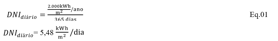
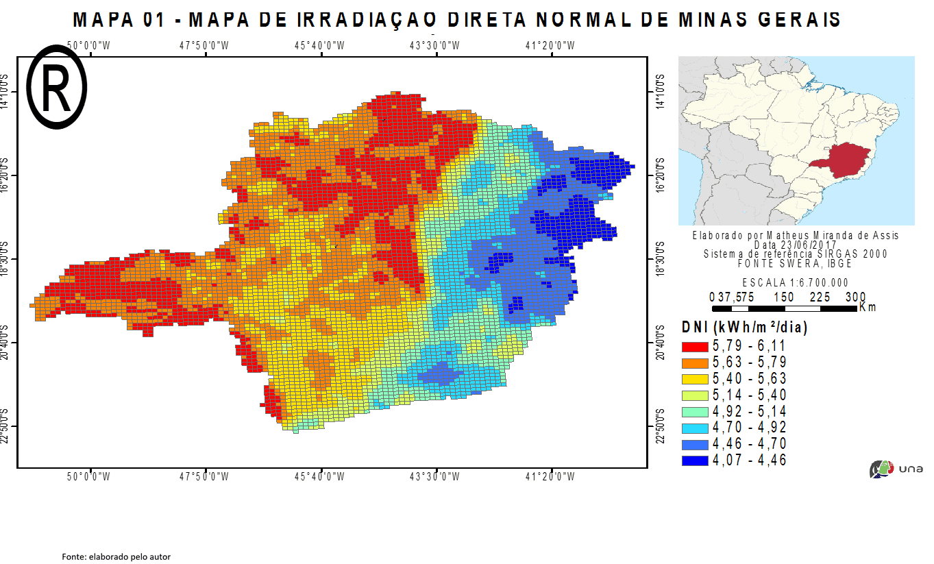
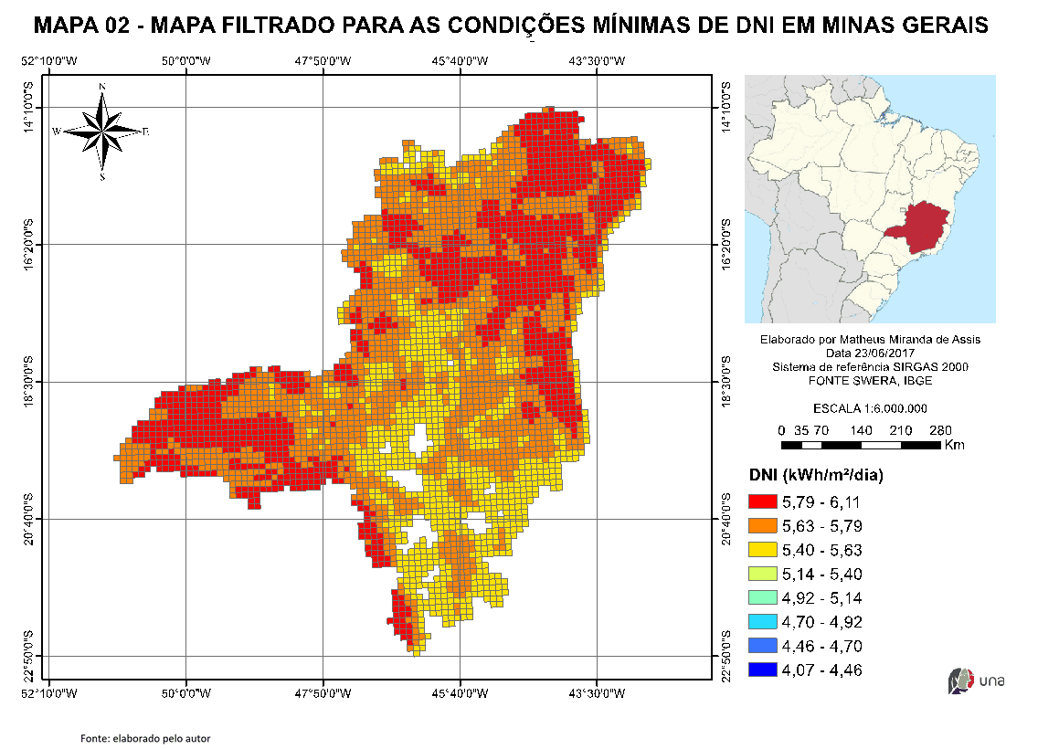
With the dni data for the state of Minas Gerais, a spatial analysis was performed by attributes, having as a condition for filtering the value of NiD equal to or greater than 5.48,
![]()
which guarantees an incidence of solar irradiation at the site of at least 2,000 and,
![]()
consequently, makes the installation project of a heliothermal plant viable, as already explained. Map 01 (Map 01 – Irradiation map of Minas Gerais state) and 02 (Map 02 – Filtered map for minimum conditions of Direct Normal Irradiation at Minas Gerais state) below illustrate the results before and after the aforementioned spatial analysis.
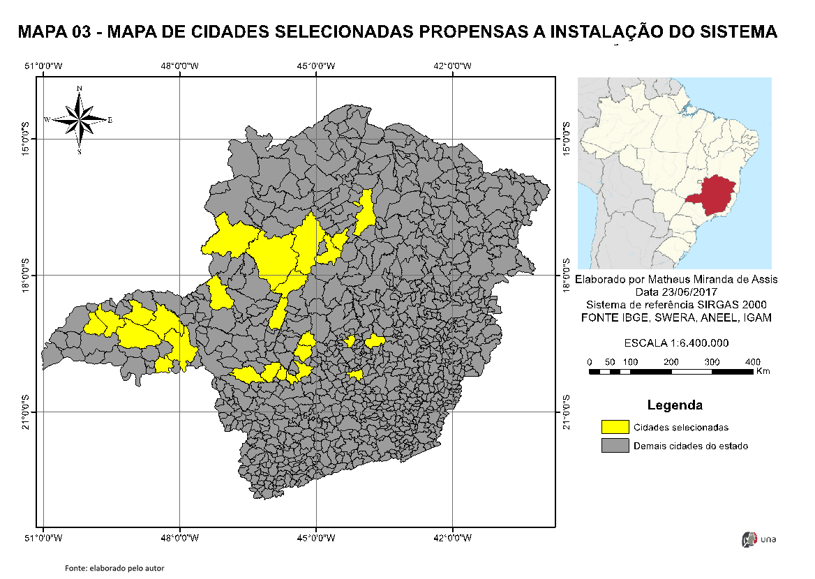
With the map constructed in the previous step (DNI values ≥ 5.48) the hydrography information and transmission lines were overtaken for the state of Minas Gerais. A new spatial analysis was performed using as parameters all DNI cells (10 km x10 km) that intercept watercourses and, from this result, all cells that intercept transmission lines. This step provided filtering sites with NID equal to or greater than 5.48 that are close to watercourses and transmission lines. Map 03 (Map 03 – Map of selected cities prone to system instalation) presents the result of this spatial analysis.
The map with the limits of municipalities of Minas Gerais was obtained from the Brazilian Institute of Statistics and Geography (IBGE). This, overlaid with the result of the previous step, identified 26 municipalities that contain cells with DNI ≥ 5.48 near watercourses and transmission lines, and, therefore, candidates for the installation of a heliothermic power plant. The result of this analysis can be seen on Map 03 below.
With a high number of sites prone to installation, a new filter was applied so that it was possible to choose a single municipality. The parameter chosen for this stage was the municipality that presented the highest concentration of industries. It is infers here that this parameter is indicative of a prosperous municipality, with an economy on the rise and that it would provide the financing of a project of this nature. In addition, the industrial complex itself could be involved in the project, arousing the costs of the installation and benefiting from the energy produced.
As a source of consultation for the identification, location and quantification of industries in Minas Gerais, we used the data made available by the Mg Industrial Registry, administered by the System of the Federation of Industries of the State of Minas Gerais (FISMG). Table 1 below provides a summary of the outcome of this consultation.
Table 1 – Number of industries in the municipalities of interest of the project in the state of Minas Gerais
| Cities | Micro | Small | Average | Great | Total |
| Uberlândia | 137 | 384 | 87 | 22 | 630 |
| Uberaba | 72 | 186 | 53 | 7 | 318 |
| Sete Lagoas | 34 | 128 | 45 | 13 | 220 |
| Montes Claros | 36 | 103 | 44 | 7 | 190 |
| Ituiutaba | 12 | 42 | 8 | 3 | 65 |
| Bom Despacho | 11 | 34 | 12 | 1 | 58 |
| Paracatu | 14 | 32 | 5 | 1 | 52 |
| João Pinheiro | 5 | 17 | 4 | 1 | 27 |
| Brumadinho | 3 | 12 | 9 | 1 | 25 |
| Várzea da Palma | 2 | 10 | 1 | 3 | 16 |
| Bambuí | 2 | 6 | 0 | 1 | 9 |
| Prata | 2 | 3 | 3 | 1 | 9 |
| Martinho Campos | 1 | 6 | 2 | 0 | 9 |
| Buritizeiro | 2 | 2 | 1 | 0 | 5 |
| Iguatama | 0 | 3 | 1 | 0 | 4 |
| Conceição das Alagoas | 0 | 2 | 1 | 0 | 3 |
| Monte Alegre de Minas | 0 | 3 | 0 | 0 | 3 |
| São Gonçalo do Abaeté | 0 | 1 | 1 | 0 | 2 |
| São Roque de Minas | 0 | 1 | 0 | 0 | 1 |
| Tiros | 0 | 0 | 1 | 0 | 1 |
Source: CADASTRO INDUSTRIAL MG, 2017
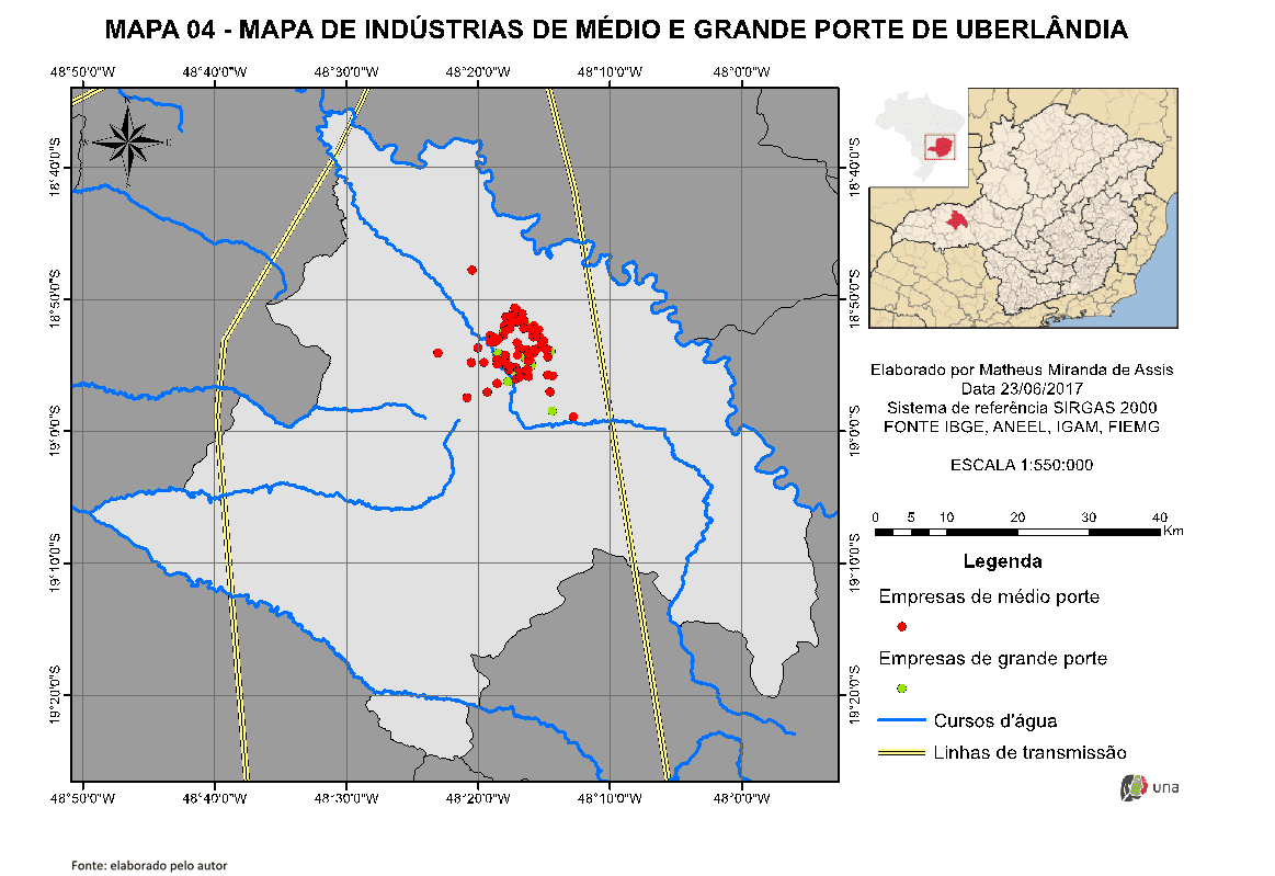
According to the observed in Table 1, Uberlândia/MG has the largest number of industries, mainly medium and large industries. Map 04 (Map 04 – Map of medium and large industries of Uberlândia city) illustrates the location of these developments in this municipality.
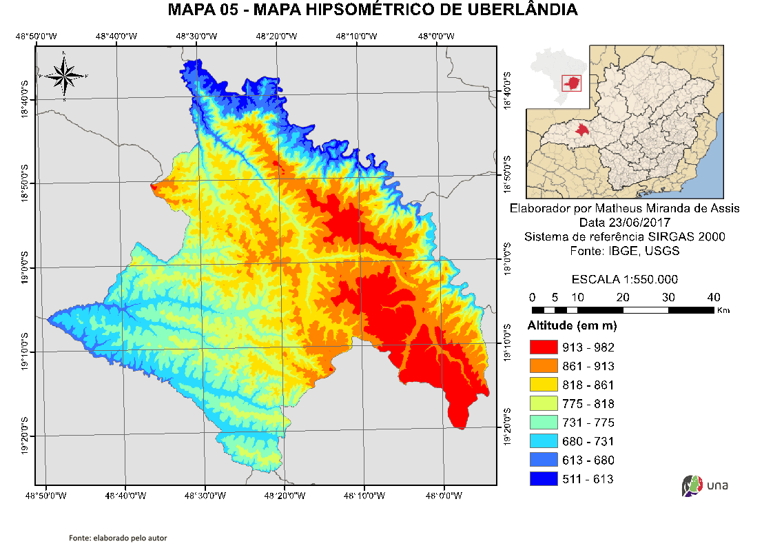
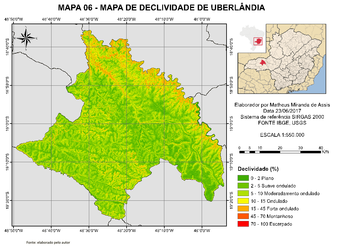
To make the hypsometric map of Uberlândia city, map 05 (Map 05 – Hypsometric map of Uberlândia city), and the map of slope Map 07 (Map 07 – Declivity map of Uberlândia city) of the municipality of Uberlândia, Map 06, radar images of Shuttle Radar Topograph Mission (SRTM) provided by the United States Geological Survey (USGS) with spatial resolution of 30 meters were used. This analysis was necessary to evaluate the regions of the municipality with the lowest rates of slope.
4. RESULTS AND DISCUSSION
Through the methodology explained in the previous item, four areas conducive to the installation of the heliothermal system in the municipality of Uberlândia/MG were identified, as shown in Map 08 (Map 8 – Declivity map of selected areas in Uberlândia city).
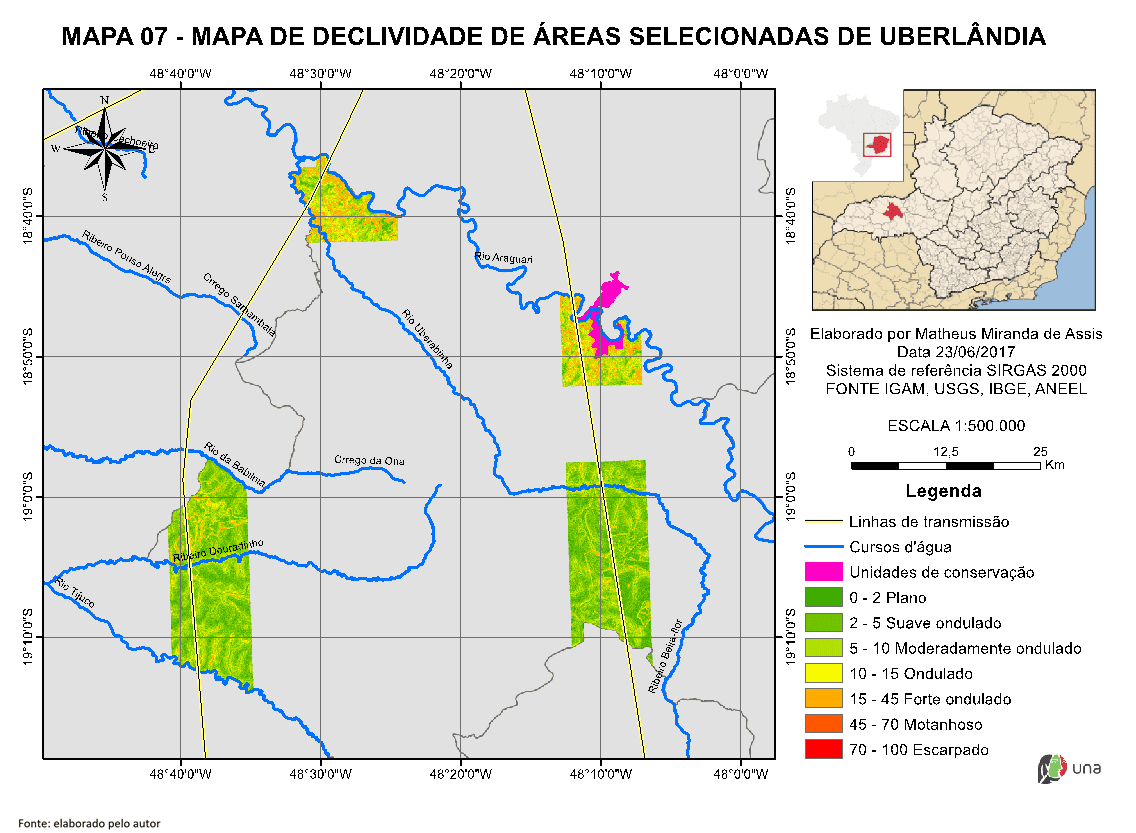
It is possible to note, in the above-mentioned map, that the two areas further north have more wavy relief; factor that could cost the installation of heliothermal plants. In addition, the region further northeast has an environmental conservation area called Pau Furado State Park; area that will be discarded due to the need for plant suppression for installation of an on-site plant. In this case, it is suggested the implementation of heliothermal plants in one of the areas south of the municipality, which present a more flat relief and proximity to watercourses and transmission lines.
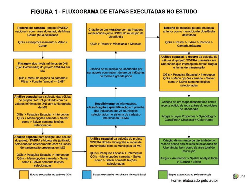
For a better understanding of the successive and chained process of spatial analysis performed in this work, a script and the functions performed are represented in a flowchart in Figure 01.
5. Conclusions
Given the local characteristics of the defined areas and heliothermal power plant technologies mentioned in item 2, it is suggested the installation of plants in the central tower model.
As described in item 2.4, the central tower model can reach temperatures up to 1,000°C. This makes it possible to use high-power turbines, enabling a high increase in efficiency in the generation of electricity. Another advantage of this model lies in the location of its heat receiver, which, because it is installed in a central area of the plant, allows greater efficiency in thermal storage, which ensures greater operating time during night periods. Finally, we highlight the low water consumption in the refrigeration process of this model, which would contribute to a lower rate of water catchment in the vicinity of the regions proposed in this study.
The crossing of all information related to radiation data and environmental factors performed in spatial analyses in Quantum Gis and ArcGis applications allowed to reduce the universe of geographic space of the state of Minas Gerais to two small areas located in the municipality of Uberlândia/MG, which present the most favorable characteristics for the implementation of a renewable energy production enterprise with the installation of a heliothermal power plant in the central tower model.
The selected areas are close to watercourses and transmission lines, which allows water to be intake and easy interconnection to the national electrical system.
Both areas are not confrontational of Conservation Units, which guarantees respect for the environment and, finally, are far from the urban perimeter, which guarantees security to the population.
6. REFERENCES
AGÊNCIA NACIONAL DE ENERGIA ELÉTRICA – ANEEL. Informações gerenciais – setembro 2016. Disponível em <http://www.aneel.gov.br/documents/656877/14854008/Boletim+de+Informações+Gerenciais+-+3°+trimestre+de+2016/a4192798-adf3-4902-b2ae-098033e69f5c>. Acessado em 14 de jun. de 2017.
ALVES, Mariana Castro. Sol, primeira fonte de luz e energia. Gênero. N° 59. Revista Pré-univesp. Julho, 2016. Disponível em: <http://pre.univesp.br/sol-primeira-fonte-de-luz-e-energia#.V-FD6GVS37M> Acesso em: 20. Set. 2016.
AZEVEDO, Verônica Wilma Bezerra. Estudo de localização de centrais termoelétricas solares de grande porte na região do semi-árido nordestino. Recife, PB. 2010.
BIANCHINI, Henrique Magalhães. Avaliação comparativa de sistemas de energia solar térmica. Rio de Janeiro, RJ. 2013.
BRASIL. Lei nº 9.985, de 18 de julho de 2000. Regulamenta o art. 225, § 1o, incisos I, II, III e VII da Constituição Federal, institui o Sistema Nacional de Unidades de Conservação da Natureza e dá outras providências. Brasília, 18 de julho de 2000.
CABRAL, Isabelle de Souza. SENNA, Pedro Rocha. TORRES, Adriana Cazelgrandi. Energia solar – Análise comparativa entre Brasil e Alemanha. Ln: IV CONGRESSO BRASILEIRO DE GESTÃO AMBIENTAL. Salvador, 2013.
CADASTRO INDUSTRIAL MG. Informação comercial atualizada e gratuita das indústrias mineiras. Disponível em <http://www.cadastroindustrialmg.com.br>. Acesso em: 16. Jun. 2017.
CAMARGOS, Ronaldo Sérgio Chacon; OLIVEIRA, Rafael Amaral de; SHAYANI, Rafael Amaral. Método para análise comparativa dos impactos técnicos da geração distribuída fotovoltaica concentrada e pulverizada. Revista Brasileira de Energia Solar, v. 7, n. 2, p. 115-122, 2017.
CEPEL, Centro de Pesquisas de Energia Elétrica. Energia Solar. [entre 2013 e 2016]. Disponível em: <http://www.cepel.br/linhas-de-pesquisa/menu/energia-solar.htm> Acesso em: 20. Set. 2016.
ENERGIA HELIOTÉRMICA. Radiação direta. 2015. Disponível em: < http://energiaheliotermica.gov.br/pt-br/glossario/radiacao-direta> Acesso em: 15 abr. 2017.
IRENA, International Renewable Energy Agency. Statistics Time Series. Disponível em: <http://resourceirena.irena.org/gateway/dashboard/?topic=4&subTopic=16> Acesso em: 15 abr. 2017.
KEMERICH, Pedro Daniel da Cunha. FLORES, Carlos Eduardo Balestrin. BORBA, Willian Fernando de. SILVEIRA, Rafael Borth da. FRANÇA, Jacson Rorigues.
KALOGIROU, S. Solar energy engineering: processes and systems. USA: Elsevier, 2009.
LODI, Cristiane. Perspectivas para a geração de energia elétrica no Brasil utilizando a tecnologia solar térmica concentrada. Rio de Janeiro, RJ. 2011.
PENAFIEL, Rafael Andrés Soria. Cenários de geração de eletricidade a partir de geradores heliotérmicos no Brasil: a influência do armazenamento de calor e da hibridização. Rio de Janeiro, RJ. 2011.
PEREIRA, Enio Bueno et al. Mapas de irradiação solar para o Brasil – Resultados do Projeto SWERA. São José dos Campos, SP. 2005.
PHILIBERT, C., FRANKL, P., DOBROTKOVA, Z.. Technology roadmap: Concentrating Solar Power. Internacional Energy Agency (IEA), 2010. Disponível em: < https://www.iea.org/publications/freepublications/publication/csp_roadmap.pdf>. Acesso em: 26. Mar. 2017.
PORTAL BRASIL. Capacidade elétrica atinge 149 mil Megawatts em novembro. Publicado: 02/01/2017. Disponível em: <http://www.brasil.gov.br/infraestrutura/2017/01/capacidade-eletrica-atinge-149-mil-megawatts-em-novembro>. Acesso em: 26. Mar. 2017.
SILVA, Manuel António Pimenta da. Central de produção de energia eléctrica a partir de energia solar térmica. Lisboa, Portugal. 2013.
SILVA, Gardenio Diogo Pimentel da. SOUZA, Marcelo José Raiol de. Análise de variáveis de projeto de sistema solar fotovoltaico utilizando o modelo SAM: uma comparação entre Belém, Fortaleza e Brasília. Belém, PA. 2013.
APPENDIX – FOOTNOTE REFERENCE
3. According to Bianchini (2013), it is currently the most used system for presenting lower thermal losses and being more economical. The Stirling engine uses heat to vary the pressure inside a sealed hydrogen chamber, making the pistons produce mechanical energy.
[1] Environmental Engineer and Sanitarist.
[2] Surveying Engineer and Analyst in development and agrarian reform.
Sent: March, 2020.
Approved: June, 2020.