THESIS
PEREIRA JÚNIOR, Antônio [1], MORALES, Gundisalvo Piratoba [2], BELTRÃO, Norma Ely Santos [3], PONTES, Altem Nascimento [4]
PEREIRA JÚNIOR et al. Application of bathymetry in water bodies in urban areas of the five Brazilian regions. Revista Científica Multidisciplinar Núcleo do Conhecimento. Year 09, Ed. 02, Vol. 02, pp. 104-138. February 2024. ISSN: 2448-0959, Acess link: https://www.nucleodoconhecimento.com.br/environmental-engineering-en/application-of-bathymetry, DOI: 10.32749/nucleodoconhecimento.com.br/environmental-engineering-en/application-of-bathymetry
ABSTRACT
The problems occurring in water bodies can be studied and researched using bathymetric data, associated or not, with geospatial technologies. The objective was to identify the application or not of this association, and the types of water bodies, in the five regions of Brazil from 2014 to 2023. The methodology employed was the combination of comparative and historical processes, using past data. The data obtained and analyzed indicated that the dichotomy between bathymetry associated with other aspects of water resources, such as turbidity, is expanding in the five Brazilian regions, especially in the northern region of the country, due to the occurrence of the largest hydrographic basin, both in extension and in water volume, which could contribute to environmental, water, and fluvial geomorphology management. However, in regions where water use is scarce due to the absence of a more expansive water network, such as the northeast region, the application of this association is still scarce. Therefore, greater employability of bathymetric data is necessary for studies and research in water bodies in both the northeast and southeast and south regions of Brazil.
Keywords: Morphometries, Bathymetric data, Water resources.
1. INTRODUCTION
This research addresses the relationship between the application of bathymetry (bathus, deep; metrori, measurement), that is, the measurement of depth in water bodies and other relevant aspects in studies and research related to water resources. These aspects have implications for water management (Bicoski et al., 2021), covering topics such as depth loss (Silva Júnior et al., 2021; Zani; Assine; Silva, 2008), variations in hydrological cycles (Gomes et al., 2023), river siltation (Andrade et al., 2021; Baraldo, 2018) which, in turn, impact the development of waterways (Melo, 2016) and the surveillance capacity of territorial waters by the armed forces (Oliveira, 2019).
Additionally, other relevant issues involve sedimentation (Reis, 2022) and contamination by minerals (Freitas et al., 2016; Wanderley et al., 2016) in water bodies. In the Brazilian context, where the extensive water network encompasses a variety of watercourses, such as bays (Silva, 2018), streams (Ponte; Brandão, 2014), estuaries (Silva et al., 2018), lakes (Barros, 2015), lagoons (Garcia et al., 2020), and reservoirs, it is evident that events such as floods/flooding (Almeida, 2020; Mantovani, 2016; Oliveira et al., 2016) and variations in flow rates (Coelho et al., 2022) can occur frequently.
Another significant challenge is related to the loss of Permanent Preservation Areas (PPAs), linked to land use and occupation (Jesus et al., 2015). In these scenarios, the lack of detailed information on hydrodynamic and hydrometric aspects compromises the affected water bodies. The lack of understanding of river dynamics represents an additional risk for these events, which can result in significant environmental and economic damage to the community, as well as losses to aquatic biota (Castro et al., 2014). Two critical factors contributing to this lack of information are financial limitations and environmental conditions, in the physical context (Souza; Pinto, 2020).
The limited availability of information is not due to a lack of technological options available, as there is a wide range of tools at disposal. Among these options, acoustic profiles (Ferreira 2020; Nobre, 2014; Silva, 2021) stand out, such as the Acoustic Doppler Current Profiler (ADCP), and software such as the Environmental Hydrodynamic Database System – SisBaHiA (França et al., 2021), among numerous alternatives.
Although these problems can be investigated and analyzed in conjunction with bathymetric data across the national territory, we still do not have a complete understanding of the extent of this association in the five regions of Brazil. It is precisely this gap that motivates the present research, whose value lies in generating data that illustrate where, how, and why this association is already occurring, as well as identifying the types of water bodies that benefit from this application.
The structure of this study was developed from: INTRODUCTION, where the theoretical framework was applied, then MATERIAL AND METHODS, which describes in detail the methodology used; next, the RESULTS, which presents the statistical analyses in the following order: spatio-temporal scale, application objectives, and application locations; this is followed by the DISCUSSION, organized by region in alphabetical order, with analyses of temporal trends in publications in each of them; right after, we have the FINAL CONSIDERATIONS, where the authors opine on the results obtained and, finally, REFERENCES.
2. MATERIALS AND METHODS
For the conduct of this research, two distinct approaches were adopted:
1) A comparative procedure was employed to observe two key elements: the application of bathymetry in conjunction with other topics related to studies and research in water bodies, covering issues such as erosion, siltation, flooding, inundations, flash floods, and other related topics.
2) A historical procedure was applied, covering the period from 2014 to 2023, as this investigation was based on academic publications discussing the relationship between these two elements. This approach aims to provide a contemporary understanding of the use of this association (UFSE, 2012).
In the context of the historical process, this constitutes the core of the corpus, as the consulted literature, including articles, monographs from four different categories, and books, provide data related to previous periods (De Luca; Lacerda; Montes, 2022; Kohls-Santos; Morosini, 2021). The compilation of these data contributes to the improvement of the state of the art in the research area, specifically regarding the use of bathymetry in studies and research in water bodies, within the time frame from 2014 to 2023 (Morosini; Fernandes, 2014).
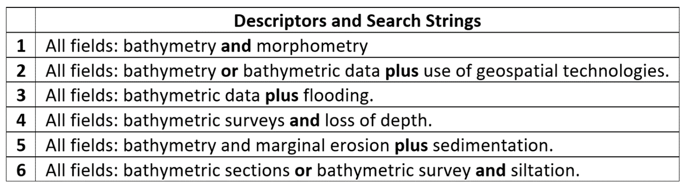
Literature search was conducted through queries to open-access electronic sources, including the website of the Coordenação de Aperfeiçoamento do Pessoal do Ensino Superior (CAPES), repositories of public universities (federal and state), and stored databases, such as the Scientific Electronic Library Online (SciELO), among others. The selective keyword used was the term ” batimetria,” along with its variants, such as “dados batimétricos,” “seções batimétricas,” and “levantamentos batimétricos.” To broaden the research, combinations of boolean terms were used, such as ” batimetria e sedimentação,” “batimetria ou levantamento batimétrico e erosão,” “dados batimétricos e assoreamentos,” and “perda da profundidade,” among others (as shown in Chart 1).
Chart 1 – Keyword and its variations, associated with other topics of studies and research in water bodies, with boolean strings
2.1 STATISTICAL ANALYSIS OF THE OBTAINED DATA
Principal Component Analysis (PCA) was applied to identify the quantitative parameters that play a significant role in the association between bathymetric data and other research topics, as well as in their application in water body studies. The identification of the values of these components followed the Kaiser Criterion (CP>1), also known as the “gold standard” (Braeken; Van Assen, 2017).
Subsequently, a Hierarchical Clustering was conducted using Euclidean distance (Marques; Chaves Neto, n.d.) to assess the similarity between the five investigated regions. Given the non-parametric nature of the data and its non-normal distribution, a boxplot was constructed with a 95% confidence interval to analyze the trends (median) and dispersion, i.e., the first and third quartiles (Valladares Neto et al., 2017), in publications over the stipulated period from 2014 to 2023.
The organization for: a) RESULTS, began with statistical analysis of the obtained data – spatio-temporal scale; objectives of the application of bathymetric data with other variables applied for studies and research; the locations of application of these studies and research, i.e., the types of water bodies; b) DISCUSSION, the authors chose to organize it in two ways: 1) by Region, in alphabetical order, from Midwest to South, and 2) by an evolutionary temporal scale of the selected literature for this topic.
3. RESULTS
3.1 STATISTICAL ANALYSIS OF THE OBTAINED DATA
3.1.1 SPATIO-TEMPORAL SCALE
The analysis of the obtained data indicated that the two principal components (PC1 and PC2) represent 85.3% of the analyzed data. After applying the Kaiser criterion (PC > 1), a minimum acceptable of around 85% of accumulated variance among the analyzed data was identified, which is useful for conducting studies of the obtained data (Table 1).
Table 1: Principal Component Analysis (PCA) for spatio-temporal data (2014 to 2023), pre-established for the five Brazilian regions
The visualization of the PCs and the formation of groups based on the data were performed through scatter plots, highlighting their positive or negative contributions to the association between bathymetric data and other research topics in water bodies (Figure 1). In the main plane, it is possible to identify two distinct groups: one in the first quadrant and another in the fourth quadrant, both positively contributing to this association. The first two principal components can explain 85.2% of the accumulated variance of the sample data (Table 1), which is quite significant in the context of multivariate analysis.
Figure 1: Spatial position of the two principal components: temporal scale, 2014 to 2023, and the five investigated Brazilian regions: Midwest (CO); Northeast (NE), North (N), Southeast (SE), and South (S)
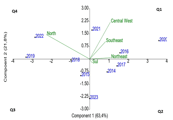
Regarding the geographical regions of Brazil, it is observed that the Midwest region shows a gradual progress in publications related to the use of bathymetric data in conjunction with other research topics, especially standing out in the years 2020 and 2021. On the other hand, the Southeast region presents a more significant frequency of such productions in the year 2016. As for the North region, the analysis indicates a gradual growth in the use of bathymetric data in association with other research topics in aquatic environments, with highlights in the years 2019 and 2022. Publications in the South region remained homogeneous over the sample period, and those in the Northeast region stood out in 2016, 2017, and 2020.
The cluster analysis revealed similarities in spatio-temporal scales among the five Brazilian regions, resulting in the formation of groups (Figure 2), which reinforces the results of the principal component analysis described in Figure 1. Notably, it was identified that the years 2015 and 2018, as well as the years 2016 and 2014, are more similar to each other. This suggests that the association between bathymetric data and studies/research in water bodies was consistently employed over three consecutive years: 2014, 2015, and 2016.
Figure 2: Similarity indices from hierarchical clustering analysis with spatio-temporal scale data: 2014 to 2023
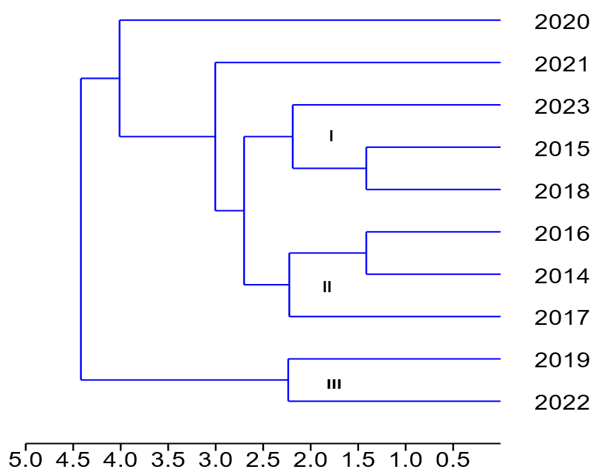
In Figure 2, the formation of three other groups is observed at the established limit, as similarity decreases, with values ranging from 2.0 to 2.5: 2023, 2017, and 2019 to 2022. This indicates that bathymetric data associated with water studies and research were not used in the years 2017 and 2023, while in the years 2019 to 2022, this association was resumed.
To visualize more clearly the dispersion of maximum and minimum quantitative values (range) over the temporal scale, these data were represented in a boxplot. The results obtained revealed that there was no uniform distribution of publications, as the interquartile ranges for bathymetric data associated with other study and research topics during the analyzed period showed significant variation (Figure 3).
Figure 3: Quantitative analysis of the distribution of publications related to the association of bathymetric data and other study and research topics in water bodies
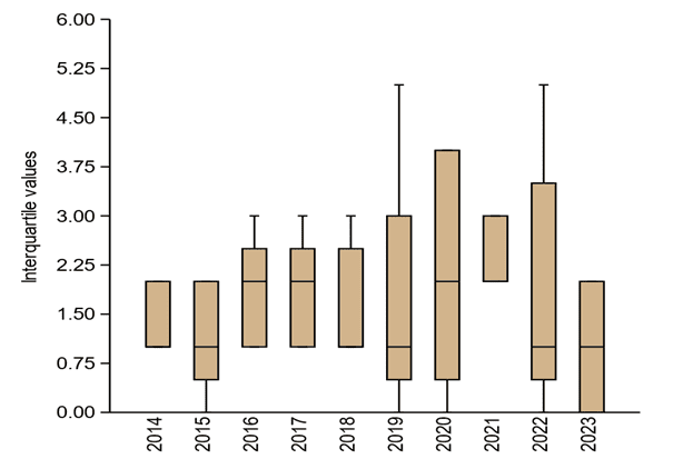
In the boxplot described in Figure 3, it is observed that from 2014 to 2018, as well as in 2021, the standard deviation and variance of the distribution of production among the regions of Brazil were relatively low, indicating a certain uniformity of production in these regions. However, in the years 2019, 2020, and 2022, the standard deviation and variance were more pronounced, reflecting a greater dispersion in the distribution of production in the regions under study.
It was also observed that, during the analyzed decade, the year 2014 presented a limited number of publications with this association (mean = 1.5). In the years 2015, 2019, 2020, 2022, and 2023, there were no publications associating bathymetric data with other study and research topics in water bodies. However, in 2019 and 2022, even after a period without the use of this association, both reached the maximum limit of publications (n=5). In contrast, the years 2016, 2017, and 2018 had a lower maximum number of publications (n=3) compared to 2019 and 2022.
3.1.2 APPLICATION OBJECTIVES
To achieve the objectives of applying bathymetric data in conjunction with other research topics in water bodies, the data analysis revealed a total of 86 distinct approaches for this association, organized into five groups. It is noteworthy that the most frequent association involved studies and research related to river dynamics and its variables (Figure 4).
Figure 4: The five groups with study and research topics associated with bathymetric data
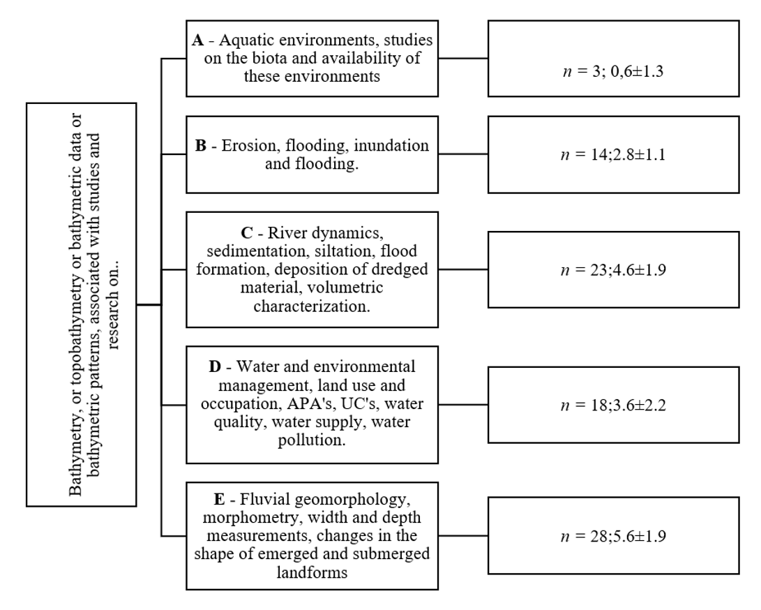
In the context of Figure 3, Group C (4.6±1.9) plays a fundamental role, especially in the Amazon basin, in the Northern region of Brazil. This is due to the importance of waterways in enabling the transportation of people and goods, as well as industrial facilities focused on commodities such as mining and soybean production, especially in the North and Midwest regions. The studies and research included in this group have a significant impact on data generation, benefiting Group D (3.6±2.2).
This statement is based on the ecosystem services provided by water bodies, including the provision of water for public supply, thermal regulation due to heat absorption capacity, and cultural value for traditional communities that hold festivities, such as honoring entities like Iemanjá, among others.
Table 2: Eigenvalues, variance, and cumulative variance of the obtained and analyzed data
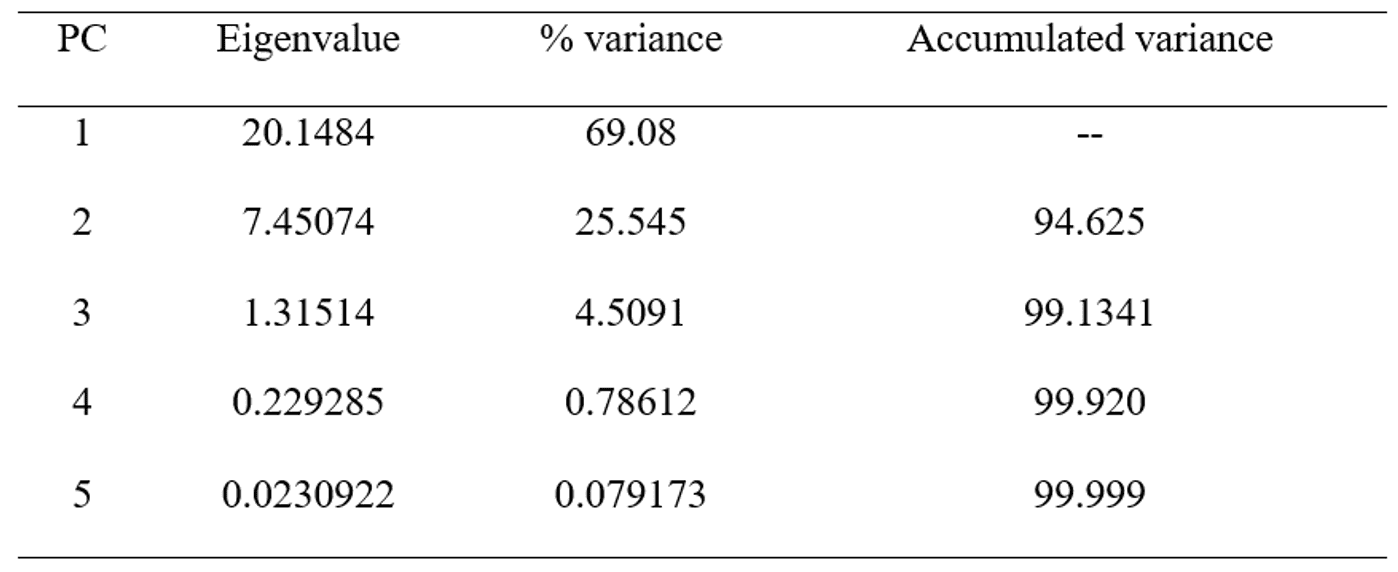
The dispersion of studies and research associated with bathymetric data in the five identified groups revealed that Group C, in the Midwest region, employed this association significantly and promptly (Figure 5).
Figure 5: Spatial position of the two principal components in relation to the five groups that applied bathymetric data to other study and research topics during the period and in the five investigated regions
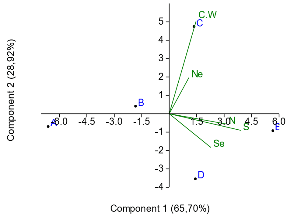
Figure 5, through its main horizontal line, highlights the progress in the use of the association in research. In the Northeast region, studies and research are gradually advancing in the application of this association with bathymetric data, especially in the São Francisco River basin, belonging to group C. On the other hand, in the North, South, and Southeast regions, we identified two groups that are using bathymetric data in studies associated with groups D and E, focusing on Water and Environmental Management, as well as geomorphological studies of water bodies.
In the North region, as well as in the Northeast, the use of this association is slower, although the most engaged groups are D and E, respectively. In the Southern region, the use is more frequent compared to the other two. On the other hand, groups A and B demonstrate a low frequency in the use of bathymetric data in water studies and research. Since three of the five groups (C, D, E) contribute positively to studies and research in water bodies, it became necessary to identify the similarities between them (Figure 6).
Figure 6: Similarity indices with the application of hierarchical clustering analysis of the five groups (A, B, C, D, E) whose studies and research were associated with the use of bathymetric data
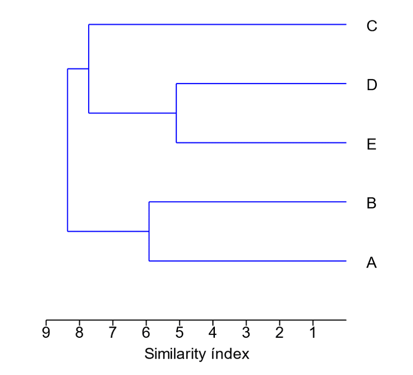
In Figure 6, it is highlighted that the groups with the highest similarity are: group D, which focuses on water and environmental management and its components, and group E, which is dedicated to fluvial geomorphology. Therefore, water resources management, encompassing aspects such as land use, conservation and monitoring of Environmental Protection Areas, water quality, and water pollution, plays a direct role in fluvial geomorphology. Furthermore, the application of bathymetry in morphometric studies, measuring width and depth, and in the maintenance and conservation of the shape of both emerged and submerged relief, is also related to these groups.
3.2 LOCATIONS OF APPLICATIONS
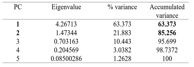
Regarding the locations of application in this investigation, they refer to the water bodies where the studies and research were conducted in the five Brazilian regions. The analysis of the obtained data identified 13 types of water bodies. However, in applying the Kaiser Criterion (CP>1), only eight were selected. Thus, the principal component analysis showed that the first two components represent 97.44% of the cumulative variance (Table 3).
Table 3: Eigenvalues, variance, and cumulative variance of the obtained data for the locations of application of studies and research associated with bathymetric data
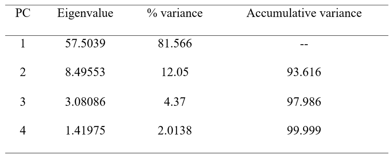
To assess spatial dispersion in the eight locations of application for studies and bathymetry in the five investigated regions, a principal component analysis was conducted. Notably, streams in the Midwest region demonstrate a significant frequency in association with other research topics (Figure 7). It is evident from the same figure that studies related to bathymetric data are positively and gradually influencing their use in studies and research in rivers in the Southeast, North, South, and Northeast regions.
Figure 7 – Spatial location of the principal components among the eight types of locations used for the application of bathymetric data and other topics of studies and research in water bodies
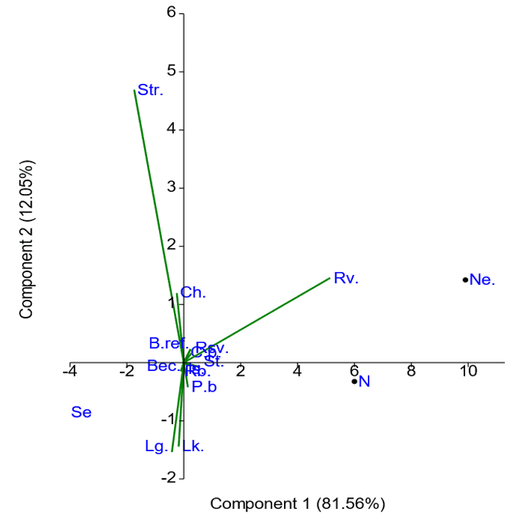
Bathymetric data in studies and research on water bodies, as indicated on the secondary horizontal axis. The greatest concern is related to “reservoirs.” This concern, especially regarding the Northeast region of Brazil, is justified by the low water availability due to the characteristics of the terrain, topography, and vegetation that significantly affect the climate. Water scarcity can be attributed to both lack of rainfall and inappropriate use of the waters of the São Francisco River, which has experienced flow alterations due to land use and occupation along its banks (França et al., 2021).
For a deeper understanding of the similarities among water bodies in the regions where studies and research were conducted, both positive and negative, a hierarchical clustering analysis was performed among the 13 identified locations in the five investigated regions (Figure 8).
Figure 8 – Hierarchical clustering analysis of the 13 locations used in studies and research associated with bathymetric data
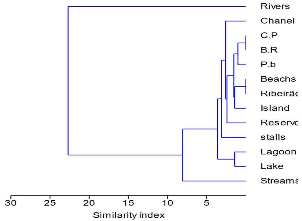
In Figure 8, we identified two similar groups: H-L and I-K. The first groups together the continental shelves and beach reefs, both submerged. This similarity stems from the fact that, when combined with bathymetric data, they play a fundamental role in water and environmental management. The coastal platform (CIRM, 1996) and beach reefs (UFS, 2015) are relevant in this context.
The second group comprises beaches, divided into three regions (shoreline, nearshore/ripples/runnel, and off-beach), along with streams, which are smaller water bodies than rivers. These elements also influence the waters of artificial beaches, such as the Taquaruçu Grande stream and Caju Beach in Tocantins (Marques et al., 2015).
4. DISCUSSION
4.1 CENTRAL-WESTERN REGION
The use of bathymetric data in the Central-Western region has been observed in various contexts, using images from orbital sensors such as the Advanced Spaceborne Thermal Emission and Reflection Radiometer (ASTER). For example, in studies of the Paraguay River in Goiás, this approach was used to measure depth with high reliability (Zani; Assine; Silva, 2008). In the municipality of Três Lagoas, Mato Grosso do Sul, at Lagoa Maior, the application of bathymetric data showed a three-meter reduction in depth in 2002. Additionally, this data has been useful in mapping areas susceptible to floods and inundations, as well as defining ranges in streams, in this state (Oliveira et al., 2016; Mantovani, 2016).
Bathymetric data also play a significant role in evaluating marginal erosions and silting in water bodies. This association has been observed in different locations, including the urban reservoir known as Lago do Amor in Mato Grosso do Sul (Alves Sobrinho et al., 2017), the Bandeira and Cabaça streams in Mato Grosso do Sul (Ferreira, 2020), and the Prosa Stream in Campo Grande, also in Mato Grosso do Sul (Bruno, 2021). The analysis of bathymetric data is also essential in studies of silting, as this phenomenon can have negative impacts on aquatic fauna and even lead to the total drying of the bed, as evidenced in Lagoa Maior, which is a Permanent Preservation Area (APP) in Mato Grosso do Sul (Souza; Pinto, 2020).
In the Central-Western Region, it is observed that the use of bathymetric data, regardless of the adoption of geospatial technologies or manual approaches, has been associated with studies related to depth, flooding, inundations, erosions, sedimentation, sediment contamination, aquatic macrofauna, and silting in rivers, streams, and reservoirs. This approach is fundamental for generating solid and substantial information, allowing water and environmental resource managers to establish effective goals in preventing irreparable economic and social losses.
4.2 NORTHEAST REGION
Studies and research associated with bathymetry have been employed to analyze the probability of flooding in rivers, such as the Mundaú and Paraíba do Meio in Alagoas (Lima, 2017a). They have also been used to consider the hypothesis of dam rupture, such as the Carpina Dam on the Capibaribe River in Pernambuco (Lambert, 2021). The application of this association reveals its usefulness in delineating river plains susceptible to flooding, as demonstrated in the Parnaíba and Poti rivers in Teresina, Piauí, and Timon, Maranhão, respectively (Souza et al., 2018).
Another relevant application is related to the conservation of aquatic biodiversity, exemplified in the Baía do Cumã, São Marcos, and São José in Maranhão (Lima, 2023, p. 33), especially in areas with frequent boat traffic, such as in Costa Branca, Rio Grande do Norte (Oliveira, 2015). Furthermore, bathymetry is valuable in water resource management, as evidenced in the Ondas River, Bahia (Castro et al., 2014). This management, when applied in medium and large reservoirs, integrating geo-environmental and water data, provides effective control of water levels in regions with high demand and low supply, such as in the Brazilian semi-arid region, where the Sobradinho and Poço da Cruz reservoirs are located in Pernambuco (Bacalhau, 2022).
In addition to the mentioned applications, this data has also been used in studies on sedimentation and metal contamination (by adsorption and/or complexation), as observed in the São Marcos Bay, Maranhão (Cunha, 2023). This contamination can negatively impact benthic fauna, including lobsters and detritivores fish, as demonstrated in research conducted on the reefs of Praia do Seixas, Paraíba (Lima, 2017b). Besides the contamination issue, sediment transport must be considered, which results in the formation of “alluviums.”
In this context, it is important to consider urban perimeters, such as in the Parnaíba River, Piauí, where there is a decrease in water velocity, leading to the concentration of pollutants and siltation (Costa, 2020; Nunes et al., 2014). Sedimentary dynamics, involving dredging for the deepening of water bodies, can also be studied through bathymetric modeling, as exemplified in the Capibaribe River, Pernambuco (Melo, 2016). This dynamic can be associated with bathymetric data for environmental studies in estuaries, which are natural sediment receivers.
The validity of this approach has been demonstrated in research conducted in the estuary of the Itapessoca River, Pernambuco, where the obtained data allowed for the elaboration of a faciological map (Oliveira, 2018). In the context of estuaries and the application of this association, studies on depth in the Poxim River, Sergipe, stand out, which, in addition to bathymetric data, incorporated information from the TM Landsat 5 sensor (Martins et al., 2020). In the scope of water resource management, the combination of this data can be applied to assess water quality, as exemplified in the Paraíba do Norte River, Paraíba (Silva, 2019).
In port areas, particularly in cases of oil spills, a lipophilic substance that affects the physical conditions of water, as occurred in the Port of Cabedelo, Paraíba, the use of bathymetric data plays a crucial role in evaluating physical and oceanographic conditions, including currents and waves (Frazão; Amaro, 2016). Additionally, this data finds application in research related to the geological processes of water bodies.
Regarding studies and research associated with bathymetry, they can be applied in estuary channels, as observed in the Coreaú River, Ceará, for investigations on land use and occupation over decades (Colares, 2015). This approach is also useful in hydrodynamic studies in reservoirs, allowing estimates of flow velocity, residence time, and water column renewal rates, as demonstrated in Redenção, Ceará (França, 2021).
4.3 NORTH REGION
In this region, the application of bathymetric data has played a significant role in clear-water rivers, such as in the lower Branco River, Acre, together with images obtained from the OLI/Landsat 8 sensor (Cremon et al., 2015). These data have also been used in comparative studies to analyze the bathymetric situation of the Madeira River in Porto Velho, Rondônia (Pinheiro et al., 2016), as well as in morphometric studies in Lagoa Paraíso, Amazonas, aiming to provide previously unavailable morphometric information for future reference (Fulan et al., 2015).
When it comes to the absence of data regarding a specific water body, the management and monitoring of situations such as erosions become challenging, as these erosions can lead to economic, cultural, and social losses, as evidenced in a study conducted in the Acará River, Pará (Fonseca et al., 2018). Therefore, the generation of bathymetric data associated with hydrodynamic data is essential for assessing the potential erosion risks in specific locations, as demonstrated in Cametá, Pará (Silva; Andrade, 2019).
In addition to contributing to the prevention of erosions, this combination of data can be applied in planning and identifying the “best practices” for mitigating actions regarding marginal decomposition, as investigated on Mosqueiro Island, Pará (Lopes, 2022). It is important to note that one of the main results of erosion in water bodies is sedimentation, and research on this phenomenon has already been conducted in the bed of the Paraná do Ramos River in Parintins, Amazonas (Ribeiro, 2018; Marques; Carvalho, 2019), and in the Portel and Marajó Bay hydrographic basin, Pará (Nobre, 2014).
Sedimentation in water bodies triggers modifications in the submerged relief, being influenced by the deposition of allochthonous materials in the channel of the water body, as documented in the Guajará Bay, Pará (Mendes; El-Robrini; Moraes, 2022). Regardless of the nature or origin of sedimentation, one of the significant concerns for water management bodies and riparian communities is the occurrence of floods, often caused by improper use and disorderly occupation of water body margins.
The challenges related to floods, resulting from land use and occupation, have been the subject of studies and research employing bathymetric data, as exemplified in Lake Tefé and Xidarini Stream, Tefé, Amazonas (Silva, 2018). This aspect is one of the focus areas of basin committees in the state of Amapá (Silva Júnior et al., 2021), along with the management of navigability risks on the Negro River, Amazonas (Oliveira, 2019), and the assessment of social challenges faced by communities after floods, as well as their perception of this phenomenon.
Regarding the study of floods, the previously analyzed and applied association was used in research conducted on both banks of the Guamá River, Belém, Pará (Sadeck et al., 2017), on the coast of the Surubim and Cipirá rivers, Itacoatiara (Souza, 2022), and at the confluence of the Negro and Solimões rivers, all in Amazonas (Lins, 2021). The objectives of these studies included the development of modeling to identify the effects of floods on communities and their cause-effect perception, as well as the behavior of the water flow in these regions.
4.4 SOUTHEAST REGION
In this region, bathymetric data has been applied in various areas, including flow quantification, as demonstrated in the municipality of Itabira, Minas Gerais, in the Cantagalo and Candidópolis streams, the latter being a water source for the municipality of Ribeira (Miranda, 2014). These studies indicated that the Cantagalo stream is the largest contributor, representing 23.37% of the municipality’s water supply. Additionally, the use of bathymetric data is also associated with coral conservation in the Armação de Búzios Environmental Protection Area, Rio de Janeiro, aiming to generate bathymetric information for future uses (Santos, 2014).
Another relevant application involved the production of the first bathymetric chart of the Edmundo Navarro de Andrade State Forest reservoir in Rio Claro, São Paulo, which included primary and secondary data (Cigagna; Bonotto; Sturaro, 2014). Bathymetric data has also been used to identify and locate contaminant sources in the Macaé River estuary, Rio de Janeiro (Parokin et al., 2015). It is important to note that such sources are numerous, especially in urban areas, due to diversified use and occupation of the land by architectural, industrial, livestock, and agricultural units, resulting in the generation of effluents and waste, including plastics, which compromise water quality.
Water quality and land use, combined with bathymetric data, have been studied in the Ribeirão Vermelho River basin, Lavras, Minas Gerais (Menezes et al., 2016). Additionally, these data can be employed in the analysis of hydro sedimentation in channels and in the identification of obstructions in water bodies, such as lagoons that communicate with the sea. Research in this direction has been conducted in Lagoa do Araruna, which connects with the Itajuru channel, Rio de Janeiro (Silva; Rosman, 2016).
In the same region, bathymetric data was used to determine three aspects of a reservoir of a Small Hydroelectric Power Plant (SHP), including the contour curve, area, and volume, in the case of the Pipoca SHP reservoir, in the Manhuaçu River basin, Minas Gerais (Minhomi; Brito; Azevedo, 2017). Subsequently, this bathymetric data was combined with geological, physical, and chemical data, along with substrate images, in two estuaries of the Itaguaré, Perequê-Mirim, and Guaratuba rivers, located in Bertioga, São Paulo. The aim was to characterize and compare these estuaries with the use of this associated data (Baraldo, 2018). Finally, bathymetric data also finds application in the study of water body sedimentation, allowing the investigation of the genesis of this phenomenon.
In Japuíba Cove, located in Angra dos Reis, Rio de Janeiro (Vieira et al., 2020), a study was conducted using the association of bathymetric data that identified anthropogenic impacts, resulting in the silting of the Gamboa and Japuíba rivers. This phenomenon was caused by disordered use and inadequate land occupation, preceded by deforestation of the Permanent Preservation Area (PPA), especially in the mangrove area. This type of inadequate land use often leads to floods. In this context, the same association was employed in a study on the Piraquê-Açu River and the Demétrio Ribeiro Stream, to determine how they contribute to flooding in the center of the municipality of João Neiva, Espírito Santo (Guzzo, 2021).
Another identified aspect is related to the deposition of dredged material from one water body into another. This association was applied in research in the Espírito Santo Continental Shelf, where the submerged relief was mapped, and geomorphological and ecological characterizations of the area were carried out (Lagedo et al., 2021). In another research, the same association was used to calculate volumes, depths (maximum and average), and margin development indexes in the so-called Parque dos Lagos, in Frutal, Minas Gerais (Martins et al., 2022).
Bathymetric data is also relevant in studies that assess variations in recreational areas, such as beaches, both in terms of shape and functioning dynamics. In a study conducted in Enseada, which encompasses two beaches, Meaípe and Maimbá, in the municipalities of Guarapari and Anchieta, Espírito Santo, the data indicated a considerable sedimentary deposition (approximately 4,103 m³) since 1981, resulting from the installation of a port area in the region (Vervloet; Prata, 2023).
4.5 SOUTH REGION
Geoecological methods play a fundamental role in obtaining bathymetric data, using altimetric data, such as those from the DTU10BAT satellite model. In the Pelotas basin, Rio Grande do Sul, this approach was complemented by gravimetric data from the EGM2008 geopotential model, aiming to study the shape structure of this basin (Gagg, 2014). Furthermore, it was observed that this association extends to data from laboratory analyses, such as physical data on water quality, including turbidity, apparent color, total solids, and electrical conductivity, as well as reflectance generated by geotechnology, such as bands 1 to 5 of the Landsat 8 satellite, in the Igapó Lake, in Londrina, Paraná. These data were used to build linear regression models (Barros, 2015).
Although obtaining data through geotechnologies can be costly, in some research, topographic equipment, such as total station, tripod, prism, and stake, were used. This was done in a study at the Municipal Artificial Lake, built in 1978, in Cascavel, Paraná, with the aim of verifying the silting in this lake, which was confirmed (Detofol; Bortolini; Felipetto, 2017). Another approach to obtaining bathymetric data is consulting the archives of water supply companies.
In a study conducted to correct surfaces according to the position of the thalweg in the Pirapó River, Maringá, Paraná, surface corrections were conducted based on the evaluation of the mean absolute error value and the mean square error value (Bolonhez; Motta; Soares, 2019). These surface adjustments can contribute to flood mitigation and can be performed with interactive neo-cartography data and virtual information, as well as with remotely controlled unmanned boats, such as the Q boat’s bathymetric data.
These associations were employed in the study of environmental disasters caused by floods in Lages, Santa Catarina (Padilha, 2018). In the case of floods, a research was conducted in the Alto Vale do Itajaí, Santa Catarina, aiming at implementing a water resources management program that can be used to predict these floods (Forster, 2019). In the context of management, it is also important to consider facultative ponds receiving treated effluents, which may accumulate sediments unevenly, as indicated in a study in Campo Mourão, Paraná (Garcia et al., 2020).
Water resources management also includes the evaluation of water quality, which can be mathematically performed through a numerical model, such as Delft-3D. A study was conducted at Lagoa da Conceição, located in Florianópolis, Santa Catarina, with the aim of verifying the distribution and the physicochemical variables that affect water quality. One of the factors that compromised water quality was land use and occupation in the watershed (Silva, 2021). In the southern region, data indicated that previously studied and researched locations are undergoing new investigations.
One of these locations is the Municipal Artificial Lake of Cascavel, which was the subject of research in 2017 to assess silting, which was confirmed. In 2022, a new study was conducted, focusing on land use and occupation and proposing mitigating measures. As a result, metals, such as Cadmium (Cd), which pose a potential risk to fauna and flora, were identified (Francesquini, 2022).
5. FINAL CONSIDERATIONS
The use of bathymetry and its related data, together or independently from innovative geotechnologies, has been observed in studies and research conducted in the five regions of Brazil over the last decade. In cases where these technologies were not associated with this data, topographic instruments were used to collect more specific information. These studies have been dedicated to investigating the causes and developing control strategies for phenomena such as erosions, flooding, floods, inundations, and flash floods, whether in natural or artificial bodies of water, such as lagoons, lakes, and water resource reservoirs.
There was almost unanimous concern for the conservation of aquatic biodiversity in all analyzed regions, especially in areas where there was siltation due to marginal erosion or the deposition of dredged materials. This scenario manifested, for example, on the Brazilian Continental Shelf, which served as a repository for this type of material. Siltation, whether from marginal erosion or dredging deposition, led to studies on the loss of depth of bodies of water and their navigability, affecting riparian communities and traditional communities that depend on artisanal fishing for subsistence and income.
In the Southeast, South, and North regions, where bodies of water share geographical borders, research has shown integrative trends. This approach can enhance the implementation of containment or mitigation measures associated with bathymetric data. However, it is still important to highlight the need to pay attention to the conservation conditions of Permanent Preservation Areas (PPAs), which are often absent due to urban growth and land occupation. This absence can exacerbate erosion and siltation problems.
It is expected that the data presented here and the selected references will be used as a subsidy for monitoring the use of bathymetric data in water and environmental management, aiming at preserving water quality and riparian forests. This, in turn, will contribute to improving buoyancy and navigability conditions, as well as maintaining Brazilian interregional waterways, preventing accidents, and minimizing anthropogenic disasters, such as flash floods and floods.
ACKNOWLEDGEMENT
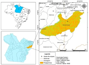
To the State University of Pará, for the doctoral scholarship granted to the first author. The data contained here are part of the thesis being developed in the Programa de Pós-Graduação em Ciências Ambientais (PPGCA) of this higher education institution. To Mr. Ruy Marcos Minto, for the numerous loans of the aluminum boat, and to Mr. Ráulison Dias Pereira (Surveying Technician), son of Mr. Constantino (in memoriam), for the technical adjustment information provided. To the Secretaria Municipal de Meio Ambiente de Paragominas (SEMMA) for the permission granted and for allowing the generation of data useful for the conservation of water resources.
REFERENCES
ALMEIDA, L. V. Q. Construção e avaliação a priori de curvas de danos residenciais diretos tangíveis relacionados a inundações para Minas Gerais. 2020. 229 f. Dissertação (Mestrado em) – Universidade Federal de Minas Gerais, Programa de Pós-Graduação em Saneamento, Meio Ambiente e Recursos Hídricos. Belo Horizonte: MG, 2020.
ALVES SOBRINHO, T. et al. Assoreamento em reservatório urbano. In: Simpósio Brasileiro de Recursos Hídricos. 20. 2017. Rio Grande do Sul. Anais eletrônicos […]. Available in: https://anais.abrhidro.org.br/events.php?fPalavra=SBRH. Access at: 22 mar. 2022.
ANDRADE, L. C et al. Avaliação de imagens com o sensor Micasense na estimativa da batimetria em corpos d’água opticamente rasos. Revista Brasileira de Cartografia, v. 73, n.° 2, p. 615-633, 2021.
BACALHAU, J. R. Caracterização volumétrica de reservatório por meio de sensoriamento remoto. 2022. Tese (Doutorado em Engenharia Civil) – Universidade Federal de Pernambuco, Centro de Tecnologia de Geociências. Recife-PE, 2022.
BARALDO, K. B. Caracterização e comparação dos estuários dos rios Itaguaré e Guaratuba (Bertioga – SP) com base nos parâmetros geo-físico-quimicos, batimetria e imageamento do fundo. 2018. 31 f. (Dissertação de Mestrado) – Universidade Estadual Paulista, Instituto de Biociências, Programa de Pós-Graduação em Biodiversidade Aquática, São Vicente-SP, 2018.
BARROS, V. D. Correlação entre fatores hidrossedimentológicos e reflectância do Lago Igapó 1 em Londrina/PR. 2015. 57 f. Monografia (Bacharelado em Engenharia Ambiental) – Universidade Federal do Paraná, Curso de Engenharia Ambiental. Londrina-PR, 2015.
BICOSKI, F. S et al. Desassoreamento e dragagem de recursos hídricos urbanos: requisitos para a operação, no âmbito municipal, no estado do Rio Grande do Sul. In: Congresso da Associação Brasileira de Engenharia Sanitária e Ambiental. 31. 2021. Paraná. Anais […]. Disponivel em: https://icongresso.abes-dn.itarget.com.br/anais/index/index/cc/9. Access at: 14 apr. 2022.
BOLONHEZ, B. F.; MOTTA, B. L.; SOARES, P. F. Aplicação de métodos de interpolação para criação de modelos digitais de elevação em trechos de captação superficial. Anuário do Instituto de Geociências, Rio de Janeiro, v. 42, n.º 1, p. 430-438, 2019.
BRAEKEN, J.; VAN ASSEN, M. A. L. An empirical Kaiser criterion. American Psychological Association, v. 22n.º3, p. 450-466, 2017.
BRUNO, L. S. Impactos econômicos e sociais de inundações em bacia hidrográfica urbana. 2021. 90 p. Dissertação (Mestrado em Tecnologias Ambientais) – Fundação Universidade Federal de Mato Grosso do Sul. Campo Grande-MS, 2021.
CASTRO, E. R. S et al. Caracterização de ambientes aquáticos no rio das Ondas, cerrado baiano. Revista Ambiente & Água, Taubaté, v. 10, n.º 1, p. 201-220, 2014.
CIGAGNA, C.; BONOTTO, D. M.; STURARO, J. R. Batimetria e estudo de parâmetros morfométricos do reservatório das Floresta Estadual “Edmundo Navarro de Andrade” (FEENA) Rio Claro/SP. Geociências, São Paulo, v. 33, n.º 4, p. 720-732, 2014.
CIRM. Comissão Interministerial para os Recursos do Mar. Plano de Levantamento da Plataforma Continental Brasileira, 1996. Available in: https://www.marinha.mil.br/secirm/pt-br/leplac. Access at: 04 abr. 2022.
COELHO, C. D. et al. Modelagem hidrodinâmica de áreas suscetíveis a inundações na bacia hidrográfica do rio Paraíba do Sul. In: Simpósio Nacional de Mecânica dos Fluídos e Hidráulica. 1. 2022. Minas Gerais. Anais eletrônicos […]. Available in: https://anais.abrhidro.org.br/jobs.php?Event=179. Access at: 12 apr. 2022.
COLARES, M. C. S. Evolução geomorfológica do canal estuarino do rio Coreaú, Ceará, Brasil. 2015. 98 f. Tese (Doutorado em Ciências Marinhas) – Universidade Federal do Ceará. Fortaleza, 2015.
COSTA, S. S. L. Estudos ambientais, caracterização sedimentológica e batimétrica do trecho urbano do rio Parnaíba, em Teresina, Piauí, Brasil. 2020. 301 f. (Tese de Doutorado) – Universidade Federal de Pernambuco, Programa de Pós-Graduação em Geociências do Centro de Tecnologia e Geociências. Recife-PE: 2020.
CREMON, E. H. et al. Modelo empírico para estimativa batimétrica em um rio amazônico de água clara. In: Simpósio Brasileiro de Sensoriamento Remoto. 17.2015. Paraíba. Anais […]. Available in: http://www.dsr.inpe.br/sbsr2015/files/p1293.pdf. Access at: 16 apr. 2022.
CUNHA, I. R. V. Distribuição espacial e avaliação de indicadores de contaminação de sedimentos por metais em um estuário tropical de macromaré, baia de São Marcos, norte do Brasil. 2023. 86 f. Dissertação (Mestrado em Geologia) – Universidade Federal do Pará. Instituo de Geociências. Belém, 2023.
DETOFOL, K.; BORTOLINI, J; FELIPETTO, H. S. Análise batimétrica do lago municipal de Cascavel – PR. Revista técnico-Científica, Curitiba, n.º 9, 2017.
FERREIRA, M. E. A. Caracterização do processo de assoreamento em reservatórios urbanos. 2020. 36 p. Dissertação (Mestrado em Tecnologias Ambientais – Universidade Federal de Mato Grosso do Sul, Campo Grande. Programa de Pós-graduação em Tecnologias Ambientais. Campo Grande-MS, 2020.
FONSECA, D. D. et al. A Utilização de batimetria no mapeamento de áreas sujeitas a erosão fluvial na Amazônia. In: Congresso Brasileiro de Geologia de Engenharia e Ambiental. 16. 2018. São Paulo. Anais […].
FORSTER, A. Estudo numérico de inundações no Alto Vale do Itajaí – SC. 2019. Dissertação (Mestrado em Modelagem computacional) – Universidade Federal do Rio Grande, Programa de Pós-graduação em Modelagem Computacional. Rio Grande, 2019.
FRANÇA, B. T, et al. Dinâmica do uso do solo e alterações na vazão na bacia do rio São Francisco no início do século XXI. REGA, v. 18, 2021.
FRANCESQUINI, M. Uso e ocupação do solo no processo de assoreamento do Lago Municipal de Cascavel – PR. 2022. Dissertação (Mestrado em Engenharia Agrícola) – Universidade Estadual do oeste do Paraná, Programa de Pós-graduação em Engenharia Agrícola. Cascavel, 2022.
FRAZÃO, L. S.; AMARO, V. E. Caracterização batimétrica e físico-oceanográfica do Porto de Cabedelo-/PB, Brasil: uma análise ambiental ao derrame de óleo. Revista Brasileira de Geomorfologia, v. 17, n. 1, p. 125-143, 2016.
FREITAS, C. M. et al. O desastre na barragem de mineração da Samarco – fratura exposta dos limites do Brasil na redução de risco de desastres. Revista Ciência & Cultura, São Paulo, v. 68, n. 3, p. 25-30, 2016.
FULAN, J. A., et al. Estudo morfométrico da Lagoa Paraíso, sul do estado do Amazonas, Brasil. Biológico, São Paulo, v. 77, n.º 1, 2015.
GAGG, G. Emprego de dados gravimétricos e de altimetria por satélite como subsídio à análise morfoestrutural na região da Bacia de Pelotas – Rio Grande do Sul. 2014. Tese (Doutorado em Ciências) – Universidade Federal do Rio Grande do Sul, Programa de Pós-graduação em Geociências. Porto Alegre, 2014.
GARCIA, L. C. et al. Análise do acúmulo de sedimentos por batimetria em lagoa facultativa no município de Campo Mourão/PR. Revista Ibero-Americana de Ciências Ambientais, Aracaju, v. 11, n.1, p. 177-183, 2020.
GOMES, E. P. et al. Uso e ocupação da terra em pequenas bacias e alterações no ciclo hidrológico local. In: SILVA, C. N. et al. (Org.). Geoinformação e análises socioambientais. Belém: GAPTA/UFPA, 2023, p. 71-96.
GUZZO, F. R. Barragem de amortecimento para conter as inundações na cidade de João Neiva/ES. 2021. Projeto multidisciplinar (Especialização em Engenharia de Infraestrutura Urbana) – Instituto Federal do Espírito Santo, Programa de Pós-graduação em Engenharia de Infraestrutura Urbana. Vitória, 2021.
JESUS, H. G. C. F. M. et al. Revisão das tecnologias utilizadas para levantamento batimétrico em corpos hídricos. Boletim do Observatório Ambiental Alberto Ribeiro Lamego, v. 9, n.° 2, p. 145-163, 2015.
KOHLS-SANTOS, P.; MOROSINI, M. C. O revisitar da metodologia do estado do conhecimento para além de uma revisão bibliográfica. Revista Panorâmica, Araguaia, v. 33, 2021.
LAGEDO, F. B. et al. Environmental characterization of a dredging disposal on the continental shelf on Espirito Santos, Brazil. Quartenary and Environmental Geosciences, Curitiba, v. 12, n.º 1, p. 18-28, 2021.
LAMBERT, M. P. Estudo dos indicadores de risco de inundação no município do Recife decorrente do rompimento hipotético da barragem de Carpina. 2021. Trabalho de Conclusão de Curso (Bacharelado em Engenharia Civil) – Universidade Federal de Pernambuco, Centro Acadêmico do Agreste. Caruaru, 2021.
LIMA, C. S. Mapeamento de inundações de áreas urbanas no entorno do CELMM. 2017. 43 f. Dissertação (Mestrado em Recursos Hídricos e Saneamento) – Universidade Federal de Alagoas – Centro de Tecnologia. Alagoas, 2017a.
LIMA, L. F. C. Diversidade, estrutura e biomassa fitoplanctônica ao longo de um continuum estuário-oceânico, sítio RAMSAR – Costa Norte Amazônica: uma abordagem temporal e espacial. 2023. Tese (Doutorado em Oceanografia) – Universidade Federal de Pernambuco, Programa de Pós-graduação em Oceanografia. Pernanbuco, 2023.
LIMA, R. C. Batimetria e análise espacial de macrobentônicos dos recifes da praia do Seixas, João Pessoa, Paraíba, Brasil. 2017. 61 f. Dissertação (Mestrado em Desenvolvimento e Meio Ambiente) – Universidade Federal da Paraíba. Paraíba, 2017b.
LINS, G. N. Modelagem hidrodinâmica do rio Amazonas entre a confluência Negro-Solimões e a foz do Madeira. 2021. 96 f. Monografia (Bacharelado em Engenharia Ambiental) – Universidade de Brasília, Departamento de Engenharia Ambiental. Brasília, 2021.
LOPES, W. F. Identificação de medidas de mitigação à erosão município de Belém, Pará, Brasil. 2022. 69f. (Trabalho de Conclusão de Curso) – Universidade Federal Rural da Amazônia. Graduação em Engenharia Ambiental e Energias Renováveis. Belém-PA, 2022.
DE LUCA, A. G.; LACERDA, L. L.; MONTES, R. Recursos didáticos inclusivos para o ensino de química/ciências e as tramas nas produções acadêmicas: uma revisão de literatura. ACTIO, Curitiba, v. 7, n.º 3, p.1-22, 2022.
MANTOVANI, J. R. O uso de geotecnologias para elaboração de um modelo de mapeamento de áreas suscetíveis à inundação e/ou alagamento, na bacia hidrográfica do Córrego Indaiá-MS. 2016. 151 p. Dissertação (Mestrado em Geografia) – Universidade Federal de Mato Grosso do Sul – Campus de Três Lagoas. Três Lagoas, 2016.
MARQUES, A. K. et al. Avaliação da qualidade da água do ribeirão Taquaruçu Grande e sua influência no reservatório da UHE Lajeado, médio Tocantins, Brasil. Revista Sodebras, v. 10, n° 117, p. 23-29, 2015.
MARQUES, J. M.; CHAVES NETO, A. Análise de agrupamento (Cluster). Material Retirado das Apostilas dos Profs. Jair Mendes Marques e Anselmo Chaves Neto,
[s.d]. Available in: https://docs.ufpr.br/~soniaisoldi/ce076/9ANALISEAGRUPAMENTOS.pdf. Access at: 30 aug. 2023.
MARQUES, R. O.; CARVALHO, J. A. L. Processos fluviais no rio Amazonas: erosão lateral e implicações para a cidade de Parintins. Revista Geonorte, v. 10, n.º 35, p. 108-132, 2019.
MARTINS, C. F. V. et al. Estimativa da profundidade do rio Poxim – SE, com dados do sensor TM Landsat 05. Anuário do Instituto de Geociências, Rio de Janeiro, b. 43, nº 3, p. 11-118, 2020.
MARTINS, H. L. et al. Represamento de veredas e conhecimento sobre a estrutura física de reservatórios rasos para mitigar impacto ambiental urbano. Engenharia Sanitária e Ambiental, Rio de Janeiro, v. 27, n.º 3, p. 625-632, 2022.
MELO, R. R. C. Modelagem batimétrica e dinâmica sedimentar do leito do rio Capibaribe após dragagem de aprofundamento. 2016. 64 f. (Dissertação de Mestrado) – Universidade Federal de Pernambuco, Programa de Pós-Graduação em Engenharia Civil, Recife-PE, 2016.
MENDES, C. A. C.; EL-ROBRINI, M.; MORAES, H. B. Dinâmica dos fundos das áreas de disposição de sedimentos dragados na Baia de Guajará, Pará, Brasil. Revista Brasileira de Geomorfologia, São Paulo, v. 23, n.º 1, 2022.
MENEZES, J. P. C. et al. Relação entre padrões de uso e ocupação do solo e qualidade da água em bacia hidrográfica urbana. Engenharia Sanitária e Ambiental, Rio de Janeiro, v. 21, n.º 3, p. 519-534, 2016.
MINHOMI, R. T.A.; BRITO, G. M.; AZEVEEDO, R. F. Uso de ecobatímetros monofeixe na determinação da curva de cota x área x volume do reservatório da PCH Pipoca – Minas Gerais – Brasil. Irriga, Botucatu, v. 22, nº 1., p. 87-100, 2017.
MIRANDA, G. O. Contribuição quantitativa dos recursos hídricos do Córrego Cantagalo para o ribeirão Candidópolis, Itabira-MG. Enciclopédia Biosfera, Goiânia, v. 10, n.º 18, p. 1042, 1051. 2014.
MOROSINI; M. C.; FERNANDES C. M. B. Estado do Conhecimento; conceitos, finalidades e interlocuções. Educação Por Escrito, Porto Alegre, c. 8, n. 2, p. 154-164, 2014.
NOBRE, A. C. L. Caracterização hídrica e sedimentar da sub-bacia de Melgaço-Pará. 2014. 66 f. Trabalho de Conclusão de Curso (Bacharel em Oceanografia) – Universidade Federal do Pará, Instituto de Geociências, Faculdade de Oceanografia. Pará, 2014.
NUNES, H. K. B. et al. Assoreamento e formação de bancos de areia no leito do rio Parnaíba, na zona urbana de Teresina-Piauí. Revista Geonorte, v. 10, n.º 1, p. 156-160, 2014.
OLIVEIRA, A. F. et al. Determinação do limite da faixa de inundação com o uso de HEC-RAS para o Parque Linear do Córrego Macambira em Goiânia, Goiás. Revista Eletrônica de Engenharia Civil, v. 11, n.° 1, p. 57-66, 2016.
OLIVEIRA, E. C. G. Gerenciamento de risco em missões de transporte logístico fluvial no eixo do rio Negro: uma proposta. 2019. 213 f. (Dissertação de Mestrado) – Escola de Aperfeiçoamento de Oficiais. Programa de Aperfeiçoamento de Oficiais em Ciências Militares, Gestão Operacional. Rio de Janeiro-RJ, 2019.
OLIVEIRA, I. T. G. Diversidade e comportamento de cetáceos associada a embarcações na bacia potiguar, Rio Grande do Norte – Brasil. 2015. 53f. Dissertação (Mestrado em Ciências Biológicas) – Universidade Federal do Rio Grande do Norte. Programa de Pós- Graduação em Ciências Biológicas. Rio Grande do Norte, 2015.
OLIVEIRA, J. A. R. Estudo sedimentológico, hidrodinâmico e ambiental do estuário do rio Itapessoca (Carrapicho e Catuamã), litoral norte de Pernambuco. 2018. Tese (Doutorado em Geociências) – Universidade Federal de Pernambuco, Programa de Pós-graduação em Geociências. Pernambuco, 2018.
PADILHA, V. L. Uso da neocartogrtafia na gestão do território. 2018. 21 f. Monografia (Especialização em Gestão Ambiental em Municípios) – Universidade Tecnológica Federal do Paraná. Paraná, 2018.
PAROKIN, R. S. et al. Análise de sensibilidade e estimação de uma fonte de contaminantes no estuário do Rio Macaé. Revista Brasileira de Recursos Hidricos, Porto Alegre, v. 20, n.º 1, p. 24-33, 2015.
PINHEIRO, J. A. C. et al. Levantamento batimétrico do rio Madeira. In: Encontro Nacional de Engenharia de Sedimentos, 12, 2016. Rondônia. Anais […]. Available in: https://rigeo.cprm.gov.br/bitstream/doc/17379/1/levantamento_bbatimetrico_rio_madeira.pdf. Access at: 12 jun. 2022.
PONTE, J. P. X.; BRANDÃO A. J. D. N. Urbanização de favelas e drenagem urbana na região metropolita de Belém. In: Encontro Nacional de Pesquisa e Pós-Graduação em Arquitetura e Urbanismo. 3. 2014. São Paulo. Anais […]. Available in: https://www.anparq.org.br/dvd-enanparq-3/htm/Artigos/ST/ST-HDC-001-2-Ponte.Brandao.pdf. Access at: 14 jun. 2022.
REIS, J. P. S. Cidades ribeirinhas da Amazônia: a relação entre produção do espaço urbano e a dinâmica fluvial da cidade de São Paulo de Olivença-AM. 2022. 172 f. (Dissertação de Mestrado) – Universidade Federal do Amazonas, Manaus, Programa de Pós-Graduação em Geografia do Instituto de Filosofia, Ciências Humanas e Sociais, Manaus-AM, 2022.
RIBEIRO, E. S. Terras caídas e seus impactos na sedimentação do leito do Paraná do Ramos/Parintins-AM. 2018. 47 f. Monografia (Bacharelado em Licenciatura Plena em Geografia) – Universidade Estadual do Amazonas, Centro de Estudos Superiores de Parintins. Amazonas, 2018.
SADECK, C. C. A. et al. A percepção social e a gestão do risco natural de cheias em áreas urbanizadas em Belém-PA. Revista de Geografia, Recife, v. 34, nº 1, p. 268-279, 2017.
SANTOS, L. G. Levantamento batimétrico da Área do Parque Natural dos Corais de Armação do Búzios, RJ. 2014. Monografia (Bacharelado em GEOLOGIA) – Universidade Federal do Rio de Janeiro, Instituto de Geociências. Rio de Janeiro, 2014.
SILVA. A. B. N.; ANDRADE, M. M. N. Identificação de risco à erosão fluvial na cidade de Cametá (PA) Brasil. Revista Delos, v.12, n.º 35, 2019.
SILVA. A. C. C. As cheias excepcionais e os impactos socioambientais na cidade de Tefé-AM. 2018. 130 f. Dissertação (Mestrado em Geografia) – Universidade Federal do Amazonas, Programa de Pós-graduação em Geografia. Amazonas, 2018.
SILVA, C. E. C. Análise hidrodinâmica e biogeoquímica de uma lacuna costeira subtropical em bacia hidrográfica urbanizada: Lagoa da Conceição, Florianópolis, Santa Catarina. 2021. 159 f. Tese (Doutorado em Engenharia Ambiental) – Universidade Federal de Santa Catarina. Programa de Pós-graduação em Engenharia Ambiental. Florianópolis, 2021.
SILVA, F. P. et al. Impacto do desassoreamento na intrusão salina em rios estuarinos urbanos: estudo de caso do rio Cubatão, SP. In: Encontro Nacional de Águas Urbanas. 12. 2018. Alagoas. Anais […]. Available in: https://anais.abrhidro.org.br/jobs.php?Event=82. [s/n]. Access at: 20 jun. 2022.
SILVA JÚNIOR, O. M. et al. Comitê de bacia hidrográfica do rio Araguari como instrumento de gestão dos recursos hídricos no estado do Amapá. Revista Brasileira de Geografia Física, Recife, v. 14, n.º 5, p. 2771-2789, 2021.
SILVA, L. M. D. Análise de circulação hidrodinâmica e de qualidade de água no sistema estuarino do rio Paraíba do Norte, PB. 2019. 150 f. Dissertação (Mestrado em engenharia Oceânica) – Universidade Federal do Rio de Janeiro, Instituto Alberto Luiz Coimbra. Rio de Janeiro, 2019.
SILVA, R. A. G.; ROSMAN, P. C. S. Viabilidade hidro-sedimentológica de um canal de maré projetado no oeste da Lagoa de Araruama – RJ. Revista Brasileira de Recursos Hídricos, Rio de Janeiro, v. 21, nº 1, p. 25-35, 2016.
SOUZA, C. D. et al. Definição da planície de inundação dos rios Parnaíba e Poti nas cidades de Teresina – PI e Timon – MA. In: Simpósio de Recursos Hídricos do Nordeste, 14. 2018. Alagoas. Anais eletrônicos […]. Available in: https://anais.abrhidro.org.br/job.php?Job=4582. Access at: 20 may 2022.
SOUZA, D. F.; PINTO, A. L. Levantamento batimétrico em ambiente lacustre brasileiro: o caso da Lagoa Maior. Revista Cerrados, Brasília, v. 18, n.º 02, p. 536-552, 2020.
SOUZA, F. D. Dinâmica fluvial do rio Amazonas e implicações socioeconômicas para a cidade de Itacoatiara-AM. 2022. 110 f. Dissertação (Mestrado em Geografia) – Universidade Federal do Amazonas, Programa de Pós-graduação em Geografia. Amazonas, 2022.
UFSE. Universidade Federal de Sergipe. Centro de Educação Superior à Distância – CESAD. Metodologia da Pesquisa. UFSE, 2012.
UFSE. Universidade Federal de Sergipe. Fundo do mar de Sergipe apresenta quatro grandes recifes submersos. UFSE, 2015. Available in: https://www.destaquenoticias.com.br/mar-de-sergipe-tem-grandes-recifes-submersos/#:~:text=Quatro%20principais%20fei%C3%A7%C3%B5es%20desse%20tipo%20est%C3%A3o%20presentes%20em,da%20Tieta%2C%20adjacente%20a%20desembocadura%20do%20rio%20Piau%C3%AD-Real. Access at: 30 apr. 2023.
VALLADARES NETO, J et al. Boxplot: um recurso gráfico para análise e interpretação de dados quantitativos. Revista de Odontologia Brasileira, v. 26, n.º 76, p. 1-6, 2017.
VERVLOET, R. J H. M.; PRATA, P. M. Alterações geomorfológicas da linha da costa após implantação de terminal portuário no litoral sul do Espírito Santo, Brasil. Geografares, Vitória, v. 3, n.º 36, p. 32. 58.
VIEIRA, Y. S.S. et al. Impacto antrópico no processo de assoreamento da enseada da Japuíba, Angra dos Reis (RJ). Revista Geociências, Rio de Janeiro, v. 39, nº 2, p. 481-491, 2020.
WANDERLEY, L. J. et al. Desastre da Samarco/Vale/BHP no Vale do rio Doce: aspectos econômicos, políticos e socioambientais. Revista Ciência & Cultura, São Paulo, v. 68, n. 3, p. 30-35, 2016.
ZANI, H.; ASSINE, M. L. SILVA, A. Batimetria fluvial estimada com dados orbitais: estudo de caso no alto curso do rio Paraguai com o sensor ASTER. Geociências, São Paulo, v. 27, n. 4, p. 555-565, 2008.
NOTE
The authors used the AI Chat GPT for spelling and grammar revision. However, all searches for content and assessment of article quality were done by the authors themselves.
[1] PhD student in Environmental Sciences, from the Postgraduate Program in Environmental Sciences (PPGCA), Master in Environmental Sciences (UFPA), Specialist in Water Planning and Management (UFAM); Specialist in Water and Environmental Management (UFPA); Environmental Management and Education Specialist (UNIASSELVI); Full Degree in Biological Sciences (UFPA). ORCID: https://orcid.org/0000-0001-6241-985X. Currículo Lattes: http://lattes.cnpq.br/3239362677711162.
[2] Advisor. PhD in Geochemical Sciences and Petrology (UFPA); Master’s degree in the same area and from the same higher education entity; Specialist in Food Technology (UFPA); Specialist in Tropical Hydrometeorology (UFPA); Specialist in Remote Sensing (UFPA); Degree in Chemistry (Universidad Pedagógica y Tecnológica de Colombia). ORCID: https://orcid.org/0000-0002-5930-7053. Currículo Lattes: http://lattes.cnpq.br/2923392000120182.
[3] Co-supervisor. Post-doctorate in Remote Sensing (Faculty of Sciences, University of Porto); PhD in Rural Development (UFRGS); Production Engineering and Civil Engineering (UFPA). ORCID: https://orcid.org/0000-0003-1991-2977. Currículo Lattes: http://lattes.cnpq.br/9434131723316393.
[4] PhD in Sciences, Physics (UNESP); Master in Geography (UFPA); Degree in Physics 9UFPA); Bachelor of Physics (UFPA). ORCID: https://orcid.org/0000-0002-9001-4603. Currículo Lattes: http://lattes.cnpq.br/5993352890364998.
Material received: 3 de novembro de 2023.
Peer-Approved Material: 8 de janeiro de 2024.
Edited material approved by the authors: 26 de fevereiro de 2024.