ORIGINAL ARTICLE
ROCHA, Wilson da Silva [1]
ROCHA, Wilson da Silva. Disordered urban growth of the Frei Calixto Complex – Baianão, Porto Seguro – BA: a study of the degradation of springs. Revista Científica Multidisciplinar Núcleo do Conhecimento. Year. 06, Ed. 12, Vol. 10, pp. 17-29. December 2021. ISSN: 2448-0959, Access link: https://www.nucleodoconhecimento.com.br/environment/disordered-urban-growth
ABSTRACT
The present work analyzed the environmental impacts of the urbanization process of the Complexo Baianão in the municipality of Porto Seguro – BA, from the intense migratory flow caused by the economic crisis of the cocoa region, affected by “witch’s broom[2]” in the 1990s. This factor led to the accelerated emergence of a complex of neighborhoods in the Permanent Preservation Area, compromising the sustainability of the springs, especially what supplies the local population. Another point raised in this investigation is the absence of public policies on the use and occupation of soil in a sustainable way, demonstrating a fragility in urban planning, forcing a portion of these migrants to occupy hillside space, thus generating socio-environmental impacts. Rapid urbanization, without proper ecological and economic urban management of the area under study has been shown to be one of the main environmental and zoning problems of the occupied areas. The problem of this study arose from two factors: the urbanization and accelerated growth of the Complexo Baianão in a Permanent Preservation Area, compromising the sustainability of the springs, especially what supplies the local population. The second factor is the absence of scientific collections on this theme. For the accomplishment of this qualitative research, bibliographic sources that deal with this theme are used, including environmental legislation, the processing of satellite images of the region investigated through the Qgis 3.12 software and field activity. The results of this research pointed out gaps in public policies that guide the use and occupation of urban areas of this neighborhood complex. In this sense, this research is considered relevant because it provides new perspectives and questions about disordered urban growth that has been compromising fragile natural systems and water flow in the municipality of Porto Seguro – BA.
Keywords: Springs, Environmental Degradation, Public Policies, Urban Growth.
1. INTRODUCTION
Porto Seguro’s accelerated urban growth process is tied to the transformation of the city by a major tourist hub. Starting with the construction of the BR-364, extension of BR-101 in 1974, through the “creation of the Master Plan of the Maritime Waterfront of Porto Seguro and Santa Cruz Cabrália. The first attempt to regulate land use and occupation in the municipality” (CARVALHO, 2008, p. 02).
In this perception, Araújo (2004, p. 145-146) states that, from the consolidation of Porto Seguro as a tourist hub in Brazil, “the municipality is seen as an area of employment opportunities”. Intensifying from the 1990s, with the witch broom crisis in the cocoa region of Bahia, the migratory flow. In this sense, the municipality becomes an area of population attraction of several regions of Brazil, and, mainly, of the extreme south of Bahia.
According to Araújo (2004), the process of formation of the Complexo Baianão did not take place from the invasion along lands near highway 367, an occupation encouraged by local politicians in environmentally fragile areas. Deforesting forests, occupying headwaters of rivers, streams and slopes, caused by suppressed land-use policies.
Thus, urban policies of land use and occupation are unnoticed from socio-environmental actions, since they are indoctrinated to capitalist interests, generating spatial segregation and environmental degradation in our country, as mentioned by Ribas (2003). Urban sprawl in a municipality of Porto Seguro – BA has neglected environmental protection areas, which has led to the notorious worsening of environmental problems.
In our studies, it was also verified that this process of disordered urbanization generated socioeconomic segregation, leading many immigrants to occupy Environmental Protection Areas (EPA), boosting negative environmental and social feedback.
[…] os instrumentos da política ambiental, por não terem sido estruturados com a lógica do ordenamento territorial que caracteriza o gerenciamento urbano, e sim das intervenções pontuais para controle e mitigação de atividades, encontram- se distantes das reais necessidades de enfrentamento dos problemas urbanos (RIBAS, 2003, p. 113).
For Guerra and Cunha (2007), failures in urban planning can generate a socio-environmental system of negative feedback, that is, the social vulnerability of these people causes environmental degradation, feeding the cycle of poverty. The urban expansion of Complexo do Baianão has caused environmental impacts, such as silting up rivers and streams, landslides on rough terrain, pollution of rivers and reduction of local biodiversity.
The problem of this study arises from some important factors, first because it is a complex of neighborhoods that arose from the occupation of immigrants. Migration driven by the witch broom crisis in the cocoa region of southern Bahia in 1990. The second factor is based on being a set of neighborhoods that had its expansion in areas of watercourses, sandy land and hillsides. Environmental protection areas that are inappropriate for urban housing, mainly occupied by a person of humble origin.
Thus, the focus of this research is to investigate, understand and analyze the degradation of on-site water sources by the process of occupation and urban expansion since 1990 in the municipality of Porto Seguro – BA. Emphasizing the importance of applicability of public policies for the occupation of urban soils, aiming at actions to mitigate and prevent the evolution of environmental degradation in this set of neighborhoods.
The methodology adopted in this study is qualitative through the case study procedure, bibliographic and documentary. Its methodological scope is explanatory, emphasizing the environmental impacts on the springs submitted by the disordered urban growth of the Complexo Baianão in the municipality of Porto Seguro – BA of the last 29 years.
In this sense, the methodology of the work was organized in two stages of exploratory studies. The first consisted of a bibliographic review of scientific works and environmental legislation, which addressed the planning of land use and occupation in Permanent Preservation Areas – PPA and references of the process of occupation and formation of this complex of neighborhoods under study.
In the second moment, the Geographic Information System (QGis 3.16.2), Shapefile files and satellite images were used for the construction of the cartographic base of the images used in the study area. Scales of 1:1000,000 and 1:100,000 were used, with the following cartographic references: EPSG:4674 – SIRGAS 2000.
In the mapping, LANDSAT images and color composition were used in the bands (1,2,5,7), respectively. After the geoprocessing of the studied area, the main watercourses and their extension were identified. Regarding anthropism, the urbanization class was adopted.
2. DEVELOPMENT
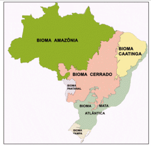
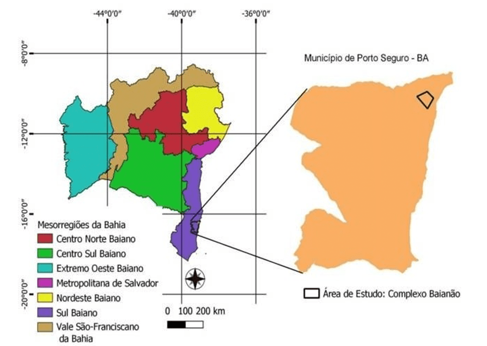
The study area of this study is the Frei Calixto – Baianão neighborhood complex in the municipality of Porto Seguro, which is located in the Southern Mesoregion of Bahia (IBGE, 2019). The perimeter researched is a space of 14.9 km2 in the northeast part of the city near BR 376, having as vegetation mosaic dense ombrófilas forests cut by water course that form the main local hydrographic network.
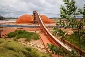
Figure 1 – Delimitation of the study area
The foundation of the neighborhood complex dates back to the beginning of 1990, according to Baianão (2013), residents already living in the city were against construction and urban development in this area, because they were humble migrants from crops in the bahian cocoa region, behind job opportunities generated by the tourism sector.
The first residents of the area under study found service, but not right to city, corroborating the arguments presented, Araújo (2005) states that this disordered urban growth is related to the omission of actions that housed this population contingent in appropriate places.
Thus, the construction of the first shacks, erected in the forested space of Atlantic Forest cut by rivers and streams, as described in Figure 02, began. Thus, we can infer that the studied space has a great hydrological diversity and, consistent with this assertion, Veracel (2011) presents the following data.
Porto Seguro destaca-se por uma enorme riqueza de recursos hídricos. Praticamente em todos os pequenos vales do município há nascentes e cursos d’água, e no território do município encontram-se 22 microbacias hidrográficas. A quase totalidade dos rios e córregos que drenam o município possui vales longos e aprofundamento médio variável, mas normalmente superior a 20 metros, e talvegues de fundo chatos preenchidos por aluviões. O padrão de drenagem observado para os cursos d’água que ocorrem na região dos tabuleiros costeiros é nitidamente dendrítico1 para os tributários de segunda ordem e preferencialmente paralelo para os cursos principais, onde observa – se certo paralelismo entre as calhas fluviais, todos drenando a área em sentido oeste-leste. Este padrão parece ser fruto apenas do controle topográfico imposto pela suave e contínua inclinação dos tabuleiros em direção leste (VERACEL, 2011, online).
In view of the above, the construction of the Complexo Baianão did not occur in a space delimited by several EPA, with the suppression of a sustainable urban zoning, because it is an area regulated by the Brazilian Forest Code in its article (4°) (Law No. 12,651, 2012). And in three decades this small urban grouping has transformed – it has become a complex with its subdivisions, as mentioned by the local prefecture.
Com o crescimento do bairro foi surgindo as divisões: Mercado do povo, Casas novas, Nilo fraga, Boqueirão, Paraguai, Areião, Parque Ecológico, Vila Vitória, Porto Alegre I e II. Além de várias praças: Praça Murici, praça do Gravata, praça da caixa d’agua, praça do coelho, praça São João, entre outras. (PREFEITURA DE PORTO SEGURO, 2021, Online).
Faced with accelerated urban growth, the Municipal Master Plan is reformulated through law no. 1511/19 establishing participatory public policies in the promotion of axes of environmental and social qualification, as mentioned in Art. 17 item I.
Promoção do desenvolvimento social, econômico e cultural baseado na sustentabilidade e na conservação da Mata Atlântica, atendendo às diretrizes e ações estabelecidas no plano municipal de Conservação e Recuperação da Mata Atlântica do Município de Porto Seguro;[…] Parágrafo único: São ações estratégicas do eixo de Qualificação Ambiental cuja a implementação deverá buscar: I – acompanhamento do plano de Recuperação das Áreas Degradadas do município, garantindo a recomposição das matas ciliares e preservação paisagísticas das falésias, bordas dos tabuleiros e faixa costeira. (PORTO SEGURO, 2019, n.p., author’s emphasis).
However, law 1511/19 remains only as technical guidelines, since there are no public or private actions that seek to develop a socio-environmental mechanism for the use and occupation of urban land engaged in Ecological – Economic Zoning and the Municipal Master Plan.
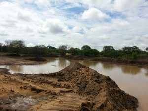
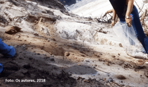
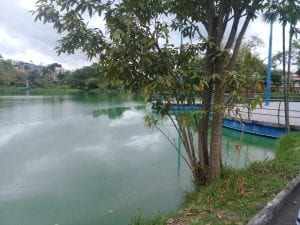
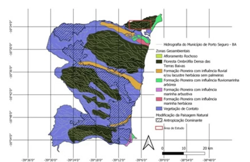
Thus, the urban expansion of the Complexo Baianão in the last 30 years and the ineffectiveness of actions aimed at sustainable urban planning have been pressing environmental preservation areas, such as the existing springs in the territory (Figure 02).
Figure 2 — Anthropologism in the hydrography of the municipality of Porto Seguro – BA
In this sense, Marroni and Asmus (2005) emphasize that the development of integrated management policies is one of the fundamental preconditions for the elaboration of actions aimed at urban planning and environmental conservation. Thus, basic socio-environmental knowledge is needed, according to Townsend et al. (2010).
Os ecossistemas naturais têm sido ameaçados por um conjunto de influências humanas, principalmente em decorrência de nosso crescimento populacional explosivo. […] Precisamos levar em consideração a extensão do problema, entender as ameaças impostas pelas atividades humanas e considerar como o conhecimento ecológico pode contribuir para a solução dos problemas ambientais. (TOWNSEND et al., 2010, p. 576).
The environmental exhaustion of the streams and rivers of the studied perimeter leads to reflection of the limitation of actions aimed at preserving the springs. In this Conception, Marroni and Asmus (2005) emphasizes that the advance of social and environmental impacts are related to changes in natural space, which was done without an urban planning integrated with sustainable development, causing environmental degradation.
The Brazilian Forest Code[3] in art. 3rd beginning II, regulates the protection of vegetation located in permanent preservation areas, which include river banks, around springs, steep slopes and hilltops. According to data published by the Municipal Atlantic Forest Recovery Plan – PMMA[4], the rivers and streams in the municipality are classified as an Environmental protection area.
However, the management of socio-environmental public policies in the urbanization of Complexo do Baianão is inoperative, contributing to accelerating the situation of social and environmental wear and tear, given that the urban zoning adopted does not include a sustainable bias, without a project of actions aimed at mitigating and preserve the riparian forests in the study area.
To Crispim et al. (2014, p.01), “The urbanization process, because it has a collective character, has the responsibility of the State as a regulatory agent, supervisor and planner”. In this sense, a reflective view of anthropism in these spaces is perceived, creating media aimed at the sustainability of land use and occupation, such as Ecological – Economic Zoning – EEZ[5].
Art. 6-A. O ZEE para fins de reconhecimento pelo Poder Público Federal deverá gerar produtos e informações nas seguintes escalas: […] III – nas escalas locais de 1:100.000 e maiores, para indicativos operacionais de gestão e ordenamento territorial, tais como, planos diretores municipais, planos de gestão ambiental e territorial locais, usos de Áreas de Preservação Permanente, nos termos do art. 4º da Lei nº 4.771, de 1965. […]. Art. 11. O ZEE dividirá o território em zonas, de acordo com as necessidades de proteção, conservação e recuperação dos recursos naturais e do desenvolvimento sustentável. […]. Art. 13. O diagnóstico a que se refere o inciso I do art. 12 deverá conter, no mínimo: […] III –Fragilidade Natural Potencial, definida por indicadores de perda da biodiversidade, vulnerabilidade natural à perda de solo, quantidade e qualidade dos recursos hídricos superficiais e subterrâneos. (Brasil, 2002, online, author’s emphasis).
Thus, the Ecological-Economic Zoning (EEZ) provides an understanding of the spatiality of environmental, economic and cultural characteristics, emerging as a normative tool of environmental and urban issues (RIBAS, 2003). Thus, the EEZ as a tool for analyzing urban management in the Complexo Baianão, which would support the problem of urban density, in the development of compensatory and preventive socio-environmental actions.
Understanding how the urban expansion of this neighborhood complex occurred, and what its growth trend is possible to understand and analyze the environmental problems caused by this growth, since urban expansion has been causing a strong pressure in the springs, especially those related to the municipality’s water supply. Figure 03 shows the urban evolution over local water sources.
Figure 3 – Evolution of the evolution of the Complexo Baianão
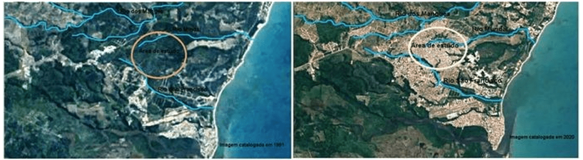
Considering the data presented in Figure 03, it is verified – it is verified that the area under study presents a trend of urban expansion with high demographic concentration, and according to Araújo (2004) real estate speculation along with socioeconomic exclusion has led people with lower incomes to occupy an area of environmental protection.
The set of economic, social and environmental problems associated with the expansion of the area under study in general entail deforestation of native vegetation, occupation of headwaters of rivers, streams and slopes, linked to the lack of policies for the use of sustainable land occupation. Such problems already affect the main municipal River, as described by the PMMA (2014).
Rio dos Mangues: Maior rio municipal; abastece a cidade de Porto Seguro; área de atuação do CEPOC legal (MDPS); apresenta horto florestal criado por lei; grande investimento da EMBASA na recuperação da mata ciliar; apresenta PSA na bacia; a foz mantém o maior mangue da orla norte; Imbiruçu de dentro – Águas do Porto. Potencial paisagístico na periferia da cidade; potencial para área protegida; educação ambiental; viveiro de mudas; água potável; parcerias com entidades (EMBASA, ONGs, MDPS, SEMA, proprietários rurais, reserva da Jaqueira). Pontos Negativos: Esgoto doméstico; degradação da mata ciliar; expansão urbana (incluindo invasões indígenas); degradação da restinga; brejos litorâneos na foz. (PMMA, 2014, p.76).
Corroborating this theme, Ab’Sáber (2003) justifies that it is necessary to know better the limitations of specific use of each landscape, because it is essential to obtain more rational knowledge of this space for the preservation of the balance of the environment.
Thus, socio-environmental planning regulates and controls the activities of individuals and groups, in which the negative effects, which may arise, are minimized and, consequently, promote a better benefit of the physical environment. By knowing the scenarios of landscape evolution over time, it is possible to understand the past, allowing us to understand the present and indicate future trends (SANTOS, 2004).
3. FINAL CONSIDERATIONS
The present work sought to make a brief analysis of the environmental impacts generated in the springs by the disordered urban growth of the Complexo Frei – Calixto Baianão, in the municipality of Porto Seguro – BA. In which it was found that their occupation and creation were unassisted from urban zoning.
However, it was necessary to reflect on the historical context, because it is a population focused on work in the municipality originating in the cocoa region of Bahia, excluded from the use and occupation of soils in the municipal master plan. It was noticed that with the expansion of this neighborhood complex in an accelerated way by real estate speculation, the poorest population was being pushed to the area of environmental protection.
Thus, this growing urban expansion has caused the degradation of local springs, resulting in the silting of streams and rivers impacting on the flow of the drainage network under study, which may cause losses in the capture and distribution of water in the municipality.
Therefore, some measures can be adopted to mitigate and prevent the impacts generated by continuous urbanization in the Complexo Baianão, such as the implementation of public policies aimed at protecting the Permanent Preservation Area, social equity and improving urban mobility, led by Ecological – Economic Zoning in the scale of 1:100,000.
REFERENCES
AB’SÁBER, AZIZ NACIB. Domínios de Natureza no Brasil, Os – Potencialidades Paisagísticas. Atelie Editorial, f. 80, 2003. 160 p.
ARAUJO, Cristina Pereira de. Porto (in) Seguro: a perda do paraíso. Os reflexos do Turismo em sua paisagem. Orientador: Dr. Paulo Renato Mesquita Pellegrino. 2004. f. Dissertação (Mestrado em Arquitetura) – Faculdade de Arquitetura e Urbanismo, Universidade de São Paulo – USP, São Paulo, 2004.
________. Um Porto Seguro para os Próximos 500 anos. Bahia análise & Dados, Salvador, v. 15, n. 2-3, p. 145, 2005.
BRASIL. Planalto. Decreto n. 4.297, de 10 de julho de 2002, dispõe do Zoneamento Ecológico – Econômico. Diário Judicial Eletrônico. Brasília, 10 de julho de 2002. Disponível em: http://www.planalto.gov.br/ civil_03/decreto/2002/ d4297.htm#:~20o%20art., que%20lhe%20confere%20o%20art. Acesso em: 15 abr. 2021.
________. Lei nº 12.651, de 25 de maio de 2012. Institui o novo código florestal brasileiro. Disponível em: < http://www.planalto.gov.br/ccivil_03/_ato2011-2014/2012/lei/l12651.htm>. Acesso em: 14 abr. 2021.
________. IBGE – Instituto Brasileiro de Geografia e Estatística . Município de Porto Seguro. online, 2021. Disponível em: ibge.gov.br/brasil/ba/porto- seguro/panorama. Acesso em: 16 jan. 2021.
________ IBGE – Instituto Brasileiro de Geografia e Estatística. MAPA Domínios Hidrogeológicos da Bahia. online, 2019. Camada shapefile. Dimensões: 1: 5 000 000. Disponível em: https://www.ibge.gov.br/geociencias /downloads-geociencias.html. Acesso em: 20 jan. 2021.
CRISPIM, Diego Lima et. al. Impactos ambientais decorrentes do uso e ocupação desordenada do espaço urbano: um estudo de caso da cidade de Baixio/CE. Revista Verde de Agroecologia e Desenvolvimento Susten, Pombal, v. 9, n. 4, p. 44-49, 15 out. 2014. Disponível em: https://www.researchgate.net/publ ication/285347150_Impactos_ambientais_decorrentes_do_uso_e_ocupacao_desord enada_do_espaco_urbano_um_estudo_de_caso_da_cidade_de_BaixioCE. Acesso em: 10 abr. 2021.
CUNHA, Sandra Baptista da; GUERRA, Antonio José Teixeira. Avaliação e perícia ambiental. 8. ed. Rio de Janeiro: Bertrand Brasil, f. 131, 2007. 261 p.
GOOGLE. Google Earth – timelapse – Porto Seguro. online. Disponível em: https://earthengine.google.com/timelapsehttps://earthengine.google.com/timelapse. Acesso em: 16 mar. 2021.
MARRONI, Etiene Villela; ASMUS, Milton Lafourcade. Gerenciamento costeiro: uma proposta para o fortalecimento comunitário na gestão ambiental. Pelotas: Editora da União Sul-Americana de Estudos da Biodiversidade, f. 75, 2005. 149 p.
OBAIANÃO. Porto Seguro, ano 2013, 2 jun. 2013. Uncategories. Disponível em: https://www.obaianao.com.br/2013/06/o-baianao-nossa-historia.html. Acesso em: 18 mar. 2021.
PORTO SEGURO. Lei nº 1511/19, Plano Diretor Municipal Participativo. Disponível em:<https://luigirotunno.com.br/wp-content/uploads/2019/01/PDMP_05122018_lei3 8_2018_Combinado.pdf>. Acesso em 18 de Set. 2021.
________. PMMA – Plano Municipal de Conservação e Recuperação da Mata Atlântica, n. 2. Diário Oficial. Porto Seguro. Disponível em: https://www.gamba.org.br/wp- content/uploads/2014/07/pmma_porto_seguro_v_2_ impressao1.pdf. Acesso em: 15 abr. 2021.
RIBAS, Otto. A sustentabilidade das cidades: Os instrumentos da gestão urbana e a construção da qualidade ambiental. Orientador. Brasília, f. 253, 2003. Tese (Mestrado em Arquitetura e Urbanismo) – Universidade de Brasília, Brasília, 2003.
ROCHA, Lurdes Bertol. A REGIÃO CACAUEIRA DA BAHIA – UMA ABORDAGEM
FENOMENOLÓGICA. Aracaju, f. 290, 2006. Tese (Organização e dinâmica dos espaços agrário e regional) – Universidade Federal de Sergipe, Aracaju, 2006. Disponível em: http://www.biblioteca.uesc.br/biblioteca/bdtd/732758856T.pdf. Acesso em: 15 mar. 2021.
SANTOS, Rozely Ferreira dos. Planejamento ambiental: teoria e prática. São Paulo: Oficina de Textos, f. 92, 2004. 184 p.
TOWNSEND, Colin R; BEGON, Michael; HARPER, John I. Fundamentos em Ecologia. Porto Alegre: Artmed Editora, v. 1, 2010. 576 p.
VERACEL CELULOSE. 2011. EIA/RIMA – Estudo de Impacto Ambiental – Relatório do Meio Físico. 538 p. (Não publicado). In BRASIL. Plano Municipal de Conservação e Recuperação da Mata Atlântica de Porto Seguro. Porto Seguro, 2014.
APPENDIX – FOOTNOTE
[2] Crise da vassoura da bruxa.
[3] Código Florestal Brasileiro.
[4] Plano Municipal de Recuperação da Mata Atlântica – PMMA.
[5] Zoneamento Ecológico-Econômico – ZEE.
[1] Postgraduate in Environmental Education and Sustainability. ORCID: 0000-0001-6745-1146.
Submitted: April, 2021.
Approved: December, 2021.